Trail Walking Antony - Coulée Verte - Photo
 aja
aja

User

© OpenStreetMap contributors
Length
Length
12.2 km
Max alt
Max alt
107 m
Uphill gradient
Uphill gradient
147 m
Km-Effort
Km-Effort  
14.2 km
Min alt
Min alt
47 m
Downhill gradient
Downhill gradient
151 m
Boucle
Boucle
No
Creation date :
2014-12-10 00:00:00.0
Updated on :
2014-12-10 00:00:00.0

(1 Reviews)

Walking
Walking
3h03
Difficulty : Easy

Scan this QR Code to open this trail in the SityTrail application

FREE GPS app for hiking

Logo SityTrail SityTrail

IGN / Geographical institutes

Download SityTrail from the App Store Download SityTrail from Google Play

Logo SityTrail SityTrail World

The world is yours!

Download SityTrail from the App Store Download SityTrail from Google Play Download SityTrail on Huawei AppGallery

About

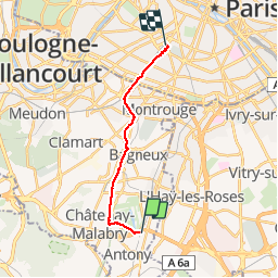
Trail Walking of 12.2 km to be discovered at Ile-de-France, Hauts-de-Seine, Antony. This trail is proposed by aja.

Description

Circuit de la Croix de Berny à la Gare Montparnasse

Elevation profile

Positioning

Country:
France
Region :
Ile-de-France
Department/Province :
Hauts-de-Seine
Municipality :
Antony
Location:
Unknown
Start:(UTM)
448918 ; 5401290 (31U) N.

Comments

Please log in to post a review or rate the element


Trails nearby

Trail Walking Verrières-le-Buisson - Sur les sentiers de découverte du Bois de Verrières - Photo
Walking
tracegps

Walking

Medium
(2)
Verrières-le-Buisson, Ile-de-France, Essonne, France
22 km | 27 km-effort
4h 40min
Yes
Trail Walking Sceaux - Les Hauts de Bièvre - Photo
Walking
tracegps

Walking

Difficult
(2)
Sceaux, Ile-de-France, Hauts-de-Seine, France
25 km | 30 km-effort
6h 0min
Yes
Trail Walking Fontenay-aux-Roses -  Rando des 3 Parcs ! (des Gares RER) - Photo
Walking
dmj41

Walking

Very difficult
(2)
Fontenay-aux-Roses, Ile-de-France, Hauts-de-Seine, France
15.9 km | 19.5 km-effort
4h 26min
No
Trail On foot Antony - Sur la Rive Gauche de la Bièvre - Photo
On foot
PRO

On foot

Easy
Antony, Ile-de-France, Hauts-de-Seine, France
5 km | 6.2 km-effort
1h 24min
No
Trail Walking Clamart - Tour des etangs - Bois de Clamart et de Meudon - Photo
Walking
GUIDE
affinetataille

Walking

Easy
Clamart, Ile-de-France, Hauts-de-Seine, France
8 km | 9.9 km-effort
2h 16min
Yes
Trail Walking Antony - De gare à gare - Photo
Walking
micheldelaramdo

Walking

Easy
(1)
Antony, Ile-de-France, Hauts-de-Seine, France
6.4 km | 7.2 km-effort
1h 29min
No
Trail Walking Sceaux - Sur les pas de Châteaubriant  - Photo
Walking
c.chehere

Walking

Medium
Sceaux, Ile-de-France, Hauts-de-Seine, France
16.7 km | 20 km-effort
4h 33min
Yes
Trail Walking Bagneux - Chatillon - Photo
Walking
c.chehere

Walking

Easy
Bagneux, Ile-de-France, Hauts-de-Seine, France
13.7 km | 16 km-effort
3h 31min
Yes
Trail Walking Palaiseau - La Troche - Photo
Walking
c.chehere

Walking

Very difficult
Palaiseau, Ile-de-France, Essonne, France
16.5 km | 20 km-effort
4h 33min
No


Close
My subscriptions