Trail Walking Guyancourt - Etangs de la Minière - Photo

Etangs de la Minière

 raivavae
raivavae

User

© OpenStreetMap contributors
Length
Length
12.4 km
Max alt
Max alt
160 m
Uphill gradient
Uphill gradient
141 m
Km-Effort
Km-Effort  
14.3 km
Min alt
Min alt
104 m
Downhill gradient
Downhill gradient
139 m
Boucle
Boucle
Yes
Creation date :
2014-12-10 00:00:00.0
Updated on :
2014-12-10 00:00:00.0

(0 Reviews)

Walking
Walking
5m
Difficulty : Easy

Scan this QR Code to open this trail in the SityTrail application

FREE GPS app for hiking

Logo SityTrail SityTrail

IGN / Geographical institutes

Download SityTrail from the App Store Download SityTrail from Google Play

Logo SityTrail SityTrail World

The world is yours!

Download SityTrail from the App Store Download SityTrail from Google Play Download SityTrail on Huawei AppGallery

About

Trail Walking of 12.4 km to be discovered at Ile-de-France, Yvelines, Guyancourt. This trail is proposed by raivavae.

Description

Parkings Croisement Sente de la Vallée  et rue Allviger et Lanot à Guyancourt

Elevation profile

Positioning

Country:
France
Region :
Ile-de-France
Department/Province :
Yvelines
Municipality :
Guyancourt
Location:
Unknown
Start:(UTM)
431156 ; 5403259 (31U) N.

Trails nearby

Trail Walking Magny-les-Hameaux - _La Vallée de la Mérantaise - Photo
Walking
GUIDE+

Walking

Easy
(5)
Magny-les-Hameaux, Ile-de-France, Yvelines, France
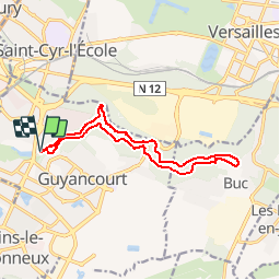
9.7 km | 11.6 km-effort
2h 30min
Yes
Trail Walking Buc - Le Tour de Satory - Photo
Walking
tracegps

Walking

Difficult
(2)
Buc, Ile-de-France, Yvelines, France
23 km | 28 km-effort
4h 49min
Yes
Trail Walking Magny-les-Hameaux - Merantaise réel - Photo
Walking
perlimpinpin59

Walking

Difficult
(1)
Magny-les-Hameaux, Ile-de-France, Yvelines, France
11.3 km | 14.2 km-effort
3h 18min
Yes
Trail Walking Guyancourt - ALBG Etang val d'or, minière - Photo
Walking
IreneProvost

Walking

Easy
(1)
Guyancourt, Ile-de-France, Yvelines, France
13.1 km | 16.1 km-effort
3h 41min
Yes
Trail Other activity Versailles - Parc de Versailles - Photo
Other activity
irokoitennis

Other activity

Very easy
(1)
Versailles, Ile-de-France, Yvelines, France
8.9 km | 9.7 km-effort
1h 49min
Yes
Trail Mountain bike Saint-Cyr-l'École - 14102013 - Photo
Mountain bike
jcvolpe

Mountain bike

Medium
(1)
Saint-Cyr-l'École, Ile-de-France, Yvelines, France
42 km | 50 km-effort
3h 11min
Yes
Trail Mountain bike Montigny-le-Bretonneux - Rando des renards 35k - Photo
Mountain bike
guariso

Mountain bike

Medium
(1)
Montigny-le-Bretonneux, Ile-de-France, Yvelines, France
38 km | 46 km-effort
2h 50min
Yes
Trail Walking Guyancourt - Etang de la Geneste - Photo
Walking
mallovon

Walking

Easy
Guyancourt, Ile-de-France, Yvelines, France
3.9 km | 4.9 km-effort
1h 11min
Yes
Trail Walking Versailles - Pièce d'eau des Suisses - Photo
Walking
mallovon

Walking

Easy
Versailles, Ile-de-France, Yvelines, France
4.2 km | 5.2 km-effort
1h 12min
Yes


Close
My subscriptions