Trail Mountain bike Arelaune-en-Seine - 1er Caux bike Ride - Vatteville la Rue - Photo

1er Caux bike Ride - Vatteville la Rue

 tracegps
tracegps

User

© OpenStreetMap contributors
Length
Length
56 km
Max alt
Max alt
148 m
Uphill gradient
Uphill gradient
943 m
Km-Effort
Km-Effort  
68 km
Min alt
Min alt
6 m
Downhill gradient
Downhill gradient
940 m
Boucle
Boucle
Yes
Creation date :
2014-12-10 00:00:00.0
Updated on :
2014-12-10 00:00:00.0

(0 Reviews)

Mountain bike
Mountain bike
4h00
Difficulty : Difficult

Scan this QR Code to open this trail in the SityTrail application

FREE GPS app for hiking

Logo SityTrail SityTrail

IGN / Geographical institutes

Download SityTrail from the App Store Download SityTrail from Google Play

Logo SityTrail SityTrail World

The world is yours!

Download SityTrail from the App Store Download SityTrail from Google Play Download SityTrail on Huawei AppGallery

About

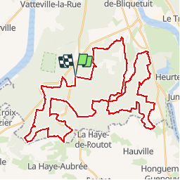
Trail Mountain bike of 56 km to be discovered at Normandy, Seine-Maritime, Arelaune-en-Seine. This trail is proposed by tracegps.

Description

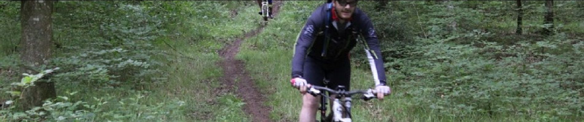
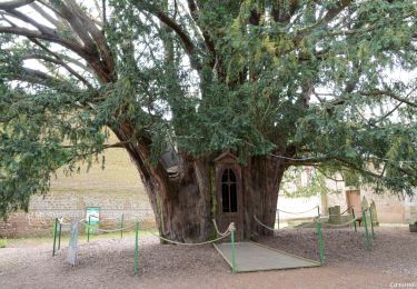
Après quelques kilomètres de mise en bouche large et roulant, nous rentrons très rapidement dans le vif du sujet. Je suis au paradis du vététiste, des singles, de belles descentes, des montées plus ou moins longues, facile, voir totalement impossible obligeant le partage. Des enchaînements qui sont bien choisis. Que du plaisir... surtout par temps sec. La suite sur le blog…

Elevation profile

Photos

Positioning

Country:
France
Region :
Normandy
Department/Province :
Seine-Maritime
Municipality :
Arelaune-en-Seine
Location:
La Mailleraye-sur-Seine
Start:(UTM)
334031 ; 5479405 (31U) N.

Trails nearby

Trail Walking La Haye-de-Routot - La Haye de Routot (32) - Photo
Walking
randovivi

Walking

Easy
(1)
La Haye-de-Routot, Normandy, Eure, France
11 km | 13.7 km-effort
2h 57min
Yes
Trail Mountain bike Vatteville-la-Rue - Foret Brotonne 2-40 - Photo
Mountain bike
tracegps

Mountain bike

Medium
(1)
Vatteville-la-Rue, Normandy, Seine-Maritime, France
40 km | 46 km-effort
4h 0min
No
Trail Equestrian Vatteville-la-Rue - rando viking - Photo
Equestrian
carriedanny

Equestrian

Medium
(1)
Vatteville-la-Rue, Normandy, Seine-Maritime, France
24 km | 30 km-effort
Unknown
Yes
Trail Walking Arelaune-en-Seine - La MAILLERAYE  9 km - Photo
Walking
MichelRando7656

Walking

Easy
Arelaune-en-Seine, Normandy, Seine-Maritime, France
9 km | 10 km-effort
2h 7min
Yes
Trail Mountain bike Vatteville-la-Rue - Randonnée en forêt de Brotonne - Photo
Mountain bike
tracegps

Mountain bike

Difficult
Vatteville-la-Rue, Normandy, Seine-Maritime, France
61 km | 73 km-effort
3h 30min
Yes
Trail Walking La Haye-de-Routot - La Haye-de-Routot - PT  - Photo
Walking
philippe76

Walking

Medium
(1)
La Haye-de-Routot, Normandy, Eure, France
6.8 km | 8.3 km-effort
1h 53min
Yes
Trail Walking La Haye-de-Routot - La Haye de Routot - Photo
Walking
MichelRando7656

Walking

Very easy
La Haye-de-Routot, Normandy, Eure, France
8.5 km | 10.1 km-effort
2h 39min
Yes
Trail Walking La Haye-de-Routot - La-Haye-de-Routot GD-11 - Photo
Walking
philippe76

Walking

Difficult
La Haye-de-Routot, Normandy, Eure, France
10.6 km | 13.1 km-effort
2h 58min
Yes
Trail Walking Arelaune-en-Seine - La-mailleraye-2 - Photo
Walking
doudet

Walking

Difficult
Arelaune-en-Seine, Normandy, Seine-Maritime, France
12.2 km | 14 km-effort
3h 10min
Yes


Close
My subscriptions