Trail Walking Pont-de-Veyle - Pont-de-Veyle et Laiz - Photo
© OpenStreetMap contributors
Length
Length
7.4 km
Max alt
Max alt
201 m
Uphill gradient
Uphill gradient
61 m
Km-Effort
Km-Effort  
8.3 km
Min alt
Min alt
174 m
Downhill gradient
Downhill gradient
60 m
Boucle
Boucle
Yes
Creation date :
2014-12-10 00:00:00.0
Updated on :
2014-12-10 00:00:00.0

(0 Reviews)

Walking
Walking
1h34
Difficulty : Very easy

Scan this QR Code to open this trail in the SityTrail application

FREE GPS app for hiking

Logo SityTrail SityTrail

IGN / Geographical institutes

Download SityTrail from the App Store Download SityTrail from Google Play

Logo SityTrail SityTrail World

The world is yours!

Download SityTrail from the App Store Download SityTrail from Google Play Download SityTrail on Huawei AppGallery

About

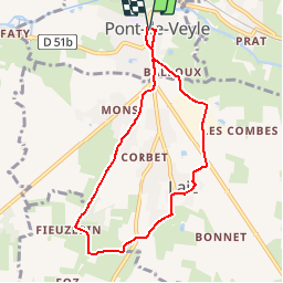
Trail Walking of 7.4 km to be discovered at Auvergne-Rhône-Alpes, Ain, Pont-de-Veyle. This trail is proposed by robertdurand.

Description

Partis de Pont-de-Veyle (Marché couvert), nous allons vers Laiz et nous contournons le village pour revenir à Pont-de-Veyle.

Elevation profile

Positioning

Country:
France
Region :
Auvergne-Rhône-Alpes
Department/Province :
Ain
Municipality :
Pont-de-Veyle
Location:
Unknown
Start:(UTM)
645438 ; 5125048 (31T) N.

Trails nearby

Trail Walking Mâcon - Macon Cluny Chalon Macon 148km - Photo
Walking
GUIDE
thonyc

Walking

Medium
Mâcon, Bourgogne-Franche-Comté, Saône-et-Loire, France
148 km | 165 km-effort
13h 44min
Yes
Trail sport Replonges - 2023-12-17_13h47m13_retour_a_laiz-18080067-1702813386-845-1 - Photo
sport
Pascale Pâris

sport

Very easy
(1)
Replonges, Auvergne-Rhône-Alpes, Ain, France
17.9 km | 19.8 km-effort
Unknown
No
Trail Walking Mâcon - Séjour RCY Les Crêtes du Haut Beaujolais -  - Photo
Walking
chessyca

Walking

Very easy
Mâcon, Bourgogne-Franche-Comté, Saône-et-Loire, France
9 km | 10.2 km-effort
1h 54min
No
Trail Walking Saint-Laurent-sur-Saône - Autour de St Laurent sur Saône - Photo
Walking
robertdurand

Walking

Very easy
Saint-Laurent-sur-Saône, Auvergne-Rhône-Alpes, Ain, France
5 km | 5.4 km-effort
1h 22min
Yes
Trail Mountain bike Saint-Laurent-sur-Saône - De Breurey lès Faverney à Vignieu en VTT- Étape 5/6 - Photo
Mountain bike
tracegps

Mountain bike

Medium
Saint-Laurent-sur-Saône, Auvergne-Rhône-Alpes, Ain, France
83 km | 93 km-effort
9h 10min
No
Trail Road bike Cormoranche-sur-Saône - 01 voie verte et bleue macon - Photo
Road bike
himba26100

Road bike

Medium
Cormoranche-sur-Saône, Auvergne-Rhône-Alpes, Ain, France
74 km | 84 km-effort
4h 45min
Yes
Trail Horseback riding Laiz - 2023-05-25_09h39m05_boucle_30_km_vonnas-7413273-1684955259-744 - Photo
Horseback riding
azipat

Horseback riding

Difficult
Laiz, Auvergne-Rhône-Alpes, Ain, France
29 km | 33 km-effort
4h 21min
Yes
Trail Horseback riding Laiz - 2023-05-25_09h38m20_laiz_vesines_34_km-16835074-1684955197-729 - Photo
Horseback riding
azipat

Horseback riding

Difficult
(1)
Laiz, Auvergne-Rhône-Alpes, Ain, France
34 km | 38 km-effort
4h 57min
No
Trail Horseback riding Laiz - 2023-05-25_09h36m55_boucle_illiat_30km-13377883-1684955247-776 - Photo
Horseback riding
azipat

Horseback riding

Difficult
Laiz, Auvergne-Rhône-Alpes, Ain, France
29 km | 34 km-effort
4h 24min
No


Close
My subscriptions