Trail Walking Belvézet -  belvezet le mas de la l''ancienne église. - Photo

belvezet le mas de la l''ancienne église.

 guignier
guignier

User

© OpenStreetMap contributors
Length
Length
13.5 km
Max alt
Max alt
271 m
Uphill gradient
Uphill gradient
307 m
Km-Effort
Km-Effort  
17.5 km
Min alt
Min alt
128 m
Downhill gradient
Downhill gradient
303 m
Boucle
Boucle
Yes
Creation date :
2014-12-10 00:00:00.0
Updated on :
2014-12-10 00:00:00.0

(0 Reviews)

Walking
Walking
3h47
Difficulty : Easy

Scan this QR Code to open this trail in the SityTrail application

FREE GPS app for hiking

Logo SityTrail SityTrail

IGN / Geographical institutes

Download SityTrail from the App Store Download SityTrail from Google Play

Logo SityTrail SityTrail World

The world is yours!

Download SityTrail from the App Store Download SityTrail from Google Play Download SityTrail on Huawei AppGallery

About

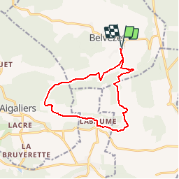
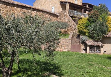
Trail Walking of 13.5 km to be discovered at Occitania, Gard, Belvézet. This trail is proposed by guignier.

Description

randonnée facile...bien repérée...sans difficulté de repérage....sauf à la fin 2 gués  à gauche on va directement au village et sur une petite route.. à droite on revient sur le début de la rando...

Elevation profile

Points of interest

Point of interest Belvézet -  - Photo
guignier
BELVÉZET 

Positioning

Country:
France
Region :
Occitania
Department/Province :
Gard
Municipality :
Belvézet
Location:
Unknown
Start:(UTM)
609896 ; 4881688 (31T) N.

Trails nearby

Trail Walking Serviers-et-Labaume - servers labame 2012 - Photo
Walking
caroline116

Walking

Medium
(2)
Serviers-et-Labaume, Occitania, Gard, France
13.8 km | 16.7 km-effort
1h 55min
Yes
Trail Walking Serviers-et-Labaume - servers labame 2012 - Photo
Walking
caroline116

Walking

Medium
(2)
Serviers-et-Labaume, Occitania, Gard, France
7 km | 8.5 km-effort
1h 56min
Yes
Trail On foot Belvézet - MONTEILLET - Photo
On foot
asclier0

On foot

Medium
Belvézet, Occitania, Gard, France
7.7 km | 10.6 km-effort
3h 0min
Yes
Trail Walking Serviers-et-Labaume - serviers - Photo
Walking
poisson1103

Walking

Very easy
Serviers-et-Labaume, Occitania, Gard, France
12.5 km | 15.2 km-effort
5h 57min
Yes
Trail Other activity Aigaliers - aigaliers - Photo
Other activity
caroline116

Other activity

Very easy
(1)
Aigaliers, Occitania, Gard, France
6.7 km | 8.7 km-effort
1h 44min
Yes
Trail Walking Serviers-et-Labaume - Randonnée en forêt de Massargues et vallée du Bourdic - Serviers et Labaume - Photo
Walking
tracegps

Walking

Medium
Serviers-et-Labaume, Occitania, Gard, France
16.3 km | 19.9 km-effort
4h 30min
Yes
Trail Walking Montaren-et-Saint-Médiers - 2024-04-02 - Photo
Walking
rando30129

Walking

Medium
Montaren-et-Saint-Médiers, Occitania, Gard, France
7.4 km | 9.5 km-effort
2h 45min
Yes
Trail Walking Belvézet - belvezet la draille des seynes - Photo
Walking
Dan30

Walking

Medium
Belvézet, Occitania, Gard, France
11.3 km | 14.4 km-effort
3h 22min
Yes
Trail Plane Montaren-et-Saint-Médiers - Circuit rallye 2022 - Photo
Plane
pchat

Plane

Montaren-et-Saint-Médiers, Occitania, Gard, France
116 km | 156 km-effort
45min
No


Close
My subscriptions