Trail Walking Longeville-lès-Metz - Metz - Bord de Moselle et canal - Photo

Metz - Bord de Moselle et canal

© OpenStreetMap contributors
Length
Length
5.3 km
Max alt
Max alt
175 m
Uphill gradient
Uphill gradient
37 m
Km-Effort
Km-Effort  
5.8 km
Min alt
Min alt
160 m
Downhill gradient
Downhill gradient
38 m
Boucle
Boucle
Yes
Creation date :
2014-12-10 00:00:00.0
Updated on :
2014-12-10 00:00:00.0

(1 Reviews)

Walking
Walking
1h18
Difficulty : Very easy

Scan this QR Code to open this trail in the SityTrail application

FREE GPS app for hiking

Logo SityTrail SityTrail

IGN / Geographical institutes

Download SityTrail from the App Store Download SityTrail from Google Play

Logo SityTrail SityTrail World

The world is yours!

Download SityTrail from the App Store Download SityTrail from Google Play Download SityTrail on Huawei AppGallery

About

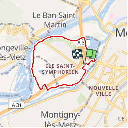
Trail Walking of 5.3 km to be discovered at Grand Est, Moselle, Longeville-lès-Metz. This trail is proposed by edmondnagel.

Description

Départ patinoire Saint Symphorien, promenade Hildegarde, rive gauche du lac, on longe la Moselle rive gauche, puis sous le pont de Verdun, on passe à côté du centre d'entrainement du FC Metz, puis on passe au-dessus de l'A31 pour longer le canal rive gauche, et le stade Saint Symphorien, puis retour à la patinoire.

Elevation profile

Positioning

Country:
France
Region :
Grand Est
Department/Province :
Moselle
Municipality :
Longeville-lès-Metz
Location:
Unknown
Start:(UTM)
292844 ; 5443825 (32U) N.

Comments

Please log in to post a review or rate the element


les cartes Sont magnifiques. Mais le mode en ligne est problématique car à chaque ouverture de l'appli, il doit tout recharger même une zone déjà visualisée. De plus, quand on se déplace un peu, il efface les zones chargées limitrophes. Du Coup, il est Tres difficile à utiliser en rando, si on n'a pas téléchargé la carte avant ( Ce qui m'arrive Souvent quand je me déplace sans avoir planifié mon voyage). Au final, j'achete la carte papier ! !


Trails nearby

Trail Walking Plappeville - Saint Quentin - Photo
Walking
edmondnagel

Walking

Medium
(1)
Plappeville, Grand Est, Moselle, France
6.9 km | 9.2 km-effort
1h 59min
Yes
Trail Walking Plappeville - Autour du fort de Plappeville. - Photo
Walking
edmondnagel

Walking

Easy
(1)
Plappeville, Grand Est, Moselle, France
8.9 km | 11 km-effort
2h 55min
Yes
Trail On foot Metz - Circuit des sentiers de Queuleu - Photo
On foot
PRO

On foot

Easy
Metz, Grand Est, Moselle, France
4.5 km | 5.2 km-effort
1h 10min
Yes
Trail On foot Lessy - Circuit de Plappeville - Photo
On foot
PRO

On foot

Easy
Lessy, Grand Est, Moselle, France
8.5 km | 11.2 km-effort
2h 32min
Yes
Trail On foot Scy-Chazelles - Circuit Robert Schuman - Photo
On foot
PRO

On foot

Easy
Scy-Chazelles, Grand Est, Moselle, France
3.5 km | 5 km-effort
1h 7min
No
Trail On foot Scy-Chazelles - Circuit du Tour du Mont St Quentin - Photo
On foot
PRO

On foot

Easy
Scy-Chazelles, Grand Est, Moselle, France
4.9 km | 6.7 km-effort
1h 31min
No
Trail Walking Metz - 20210723 - METZ - Promenade des remparts - 6 Km - Photo
Walking
GUIDE
pierreh01

Walking

Very easy
Metz, Grand Est, Moselle, France
5.7 km | 6.6 km-effort
1h 45min
Yes
Trail Walking Saulny - plesnois - Photo
Walking
pistou

Walking

Medium
(2)
Saulny, Grand Est, Moselle, France
5.8 km | 7.9 km-effort
1h 24min
Yes
Trail Mountain bike Metz - MetzGare-PAM - Photo
Mountain bike
PhilippeC54

Mountain bike

Easy
(1)
Metz, Grand Est, Moselle, France
30 km | 33 km-effort
Unknown
No


Close
My subscriptions