Trail Walking Vals-près-le-Puy - LE PUY LE BOUCHET via GR700 - Photo
 svp59
svp59

User

© OpenStreetMap contributors
Length
Length
25 km
Max alt
Max alt
1220 m
Uphill gradient
Uphill gradient
838 m
Km-Effort
Km-Effort  
35 km
Min alt
Min alt
657 m
Downhill gradient
Downhill gradient
279 m
Boucle
Boucle
No
Creation date :
2014-12-10 00:00:00.0
Updated on :
2014-12-10 00:00:00.0

(1 Reviews)

Walking
Walking
7h39
Difficulty : Medium

Scan this QR Code to open this trail in the SityTrail application

FREE GPS app for hiking

Logo SityTrail SityTrail

IGN / Geographical institutes

Download SityTrail from the App Store Download SityTrail from Google Play

Logo SityTrail SityTrail World

The world is yours!

Download SityTrail from the App Store Download SityTrail from Google Play Download SityTrail on Huawei AppGallery

About

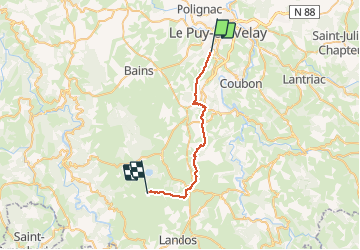
Trail Walking of 25 km to be discovered at Auvergne-Rhône-Alpes, Haute-Loire, Vals-près-le-Puy. This trail is proposed by svp59.

Elevation profile

Positioning

Country:
France
Region :
Auvergne-Rhône-Alpes
Department/Province :
Haute-Loire
Municipality :
Vals-près-le-Puy
Location:
Unknown
Start:(UTM)
569036 ; 4986277 (31T) N.

Comments

Please log in to post a review or rate the element


Balade sympa avec pas mal de chemins. Rando faite avec VTT AE.


Trails nearby

Trail Walking Le Puy-en-Velay - Compostelle : 1-Le Puy en Vely - St Didier d'Allier - Photo
Walking
prv

Walking

Very easy
(1)
Le Puy-en-Velay, Auvergne-Rhône-Alpes, Haute-Loire, France
31 km | 41 km-effort
8h 54min
No
Trail Walking Le Puy-en-Velay - Puy en velay - St Privat d'Allier - Chemin de Compostelle - Photo
Walking
tracegps

Walking

Very difficult
(2)
Le Puy-en-Velay, Auvergne-Rhône-Alpes, Haute-Loire, France
24 km | 32 km-effort
6h 4min
No
Trail Walking Le Puy-en-Velay - Le Puy Saugue Avril 2018 - Photo
Walking
GUIDE
Kargil

Walking

Difficult
Le Puy-en-Velay, Auvergne-Rhône-Alpes, Haute-Loire, France
44 km | 62 km-effort
13h 51min
No
Trail Walking Polignac - Polignac-La Source_9,7 km - Photo
Walking
Pousscailleux

Walking

Medium
(2)
Polignac, Auvergne-Rhône-Alpes, Haute-Loire, France
9.7 km | 13.8 km-effort
3h 8min
Yes
Trail Walking Le Puy-en-Velay - Compostelle 5 GR65 - Photo
Walking
Landreger

Walking

Medium
(4)
Le Puy-en-Velay, Auvergne-Rhône-Alpes, Haute-Loire, France
115 km | 154 km-effort
Unknown
No
Trail Walking Polignac - Polignac  - Photo
Walking
boyer43

Walking

Very difficult
(1)
Polignac, Auvergne-Rhône-Alpes, Haute-Loire, France
22 km | 30 km-effort
6h 47min
Yes
Trail Walking Coubon - Château de Lavalette circuit - Photo
Walking
Jean-MarieFaux

Walking

Very easy
Coubon, Auvergne-Rhône-Alpes, Haute-Loire, France
7 km | 9.5 km-effort
2h 27min
Yes
Trail Electric bike Le Puy-en-Velay - Barrage de lavalette - Photo
Electric bike
ricou1964

Electric bike

Difficult
Le Puy-en-Velay, Auvergne-Rhône-Alpes, Haute-Loire, France
94 km | 114 km-effort
4h 54min
Yes
Trail Electric bike Le Puy-en-Velay - Le puy en Velay \ Lac de Malaguet  - Photo
Electric bike
ricou1964

Electric bike

Difficult
Le Puy-en-Velay, Auvergne-Rhône-Alpes, Haute-Loire, France
85 km | 105 km-effort
4h 34min
Yes


Close
My subscriptions