Trail Walking Épeigné-les-Bois - Épeigné-les-Bois - Photo
 LEMENIO
LEMENIO

User

© OpenStreetMap contributors
Length
Length
11.5 km
Max alt
Max alt
142 m
Uphill gradient
Uphill gradient
168 m
Km-Effort
Km-Effort  
13.8 km
Min alt
Min alt
78 m
Downhill gradient
Downhill gradient
164 m
Boucle
Boucle
Yes
Creation date :
2014-12-10 00:00:00.0
Updated on :
2014-12-10 00:00:00.0

(0 Reviews)

Walking
Walking
2h59
Difficulty : Easy

Scan this QR Code to open this trail in the SityTrail application

FREE GPS app for hiking

Logo SityTrail SityTrail

IGN / Geographical institutes

Download SityTrail from the App Store Download SityTrail from Google Play

Logo SityTrail SityTrail World

The world is yours!

Download SityTrail from the App Store Download SityTrail from Google Play Download SityTrail on Huawei AppGallery

About

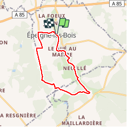
Trail Walking of 11.5 km to be discovered at Centre-Loire Valley, Indre-et-Loire, Épeigné-les-Bois. This trail is proposed by LEMENIO.

Description

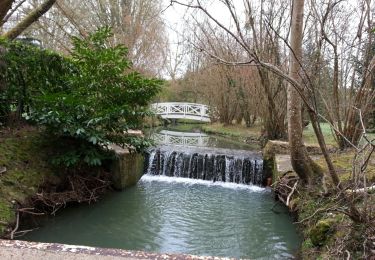
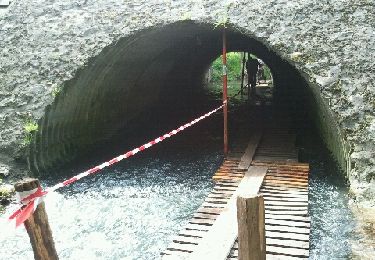
Départ parking du plan d'eau. Télécharger le dépliant touristique du circuit en cliquant sur l'icône signalant sur la carte ci-contre la source ST AIGNAN.                                     Curiosité : En face de l'église remarquez la pancarte qui indique la source et le petit portail bleu. Descendre les escaliers qui mènent à la source. Allumer l'éclairage en appuyant sur l'interrupteur qui se trouve à l'entrée de la grotte (à gauche).Ensuite à mi-parcours vous apercevrez la château de Montpoupon dans la verdure (cliquer sur l'icône pour voir les photos).Retour en longeant l'étang.


Elevation profile

Photos

Points of interest

Point of interest Épeigné-les-Bois - Source ST AIGNAN - Photo
LEMENIO
ÉPEIGNÉ-LES-BOIS 
Point of interest Céré-la-Ronde - Château de Montpoupon - Photo
LEMENIO
CÉRÉ-LA-RONDE 

Positioning

Country:
France
Region :
Centre-Loire Valley
Department/Province :
Indre-et-Loire
Municipality :
Épeigné-les-Bois
Location:
Unknown
Start:(UTM)
357385 ; 5238031 (31T) N.

Trails nearby

Trail Walking Luzillé - les petits gars - Photo
Walking
jeepee93

Walking

Very easy
(1)
Luzillé, Centre-Loire Valley, Indre-et-Loire, France
6.7 km | 7.3 km-effort
2h 13min
Yes
Trail Walking Francueil - Chenonceaux - GR41 Francueil - 12.7km 160m 2h45 - 2022 01 01 - Photo
Walking
Orcal37

Walking

Easy
Francueil, Centre-Loire Valley, Indre-et-Loire, France
12.7 km | 14.8 km-effort
2h 45min
Yes
Trail Walking Saint-Georges-sur-Cher - Saint-Georges-sur-Cher - Photo
Walking
Orcal37

Walking

Easy
Saint-Georges-sur-Cher, Centre-Loire Valley, Loir-et-Cher, France
12.4 km | 14.1 km-effort
2h 30min
Yes
Trail Walking Francueil - francueuil - Photo
Walking
jeepee93

Walking

Easy
Francueil, Centre-Loire Valley, Indre-et-Loire, France
13.7 km | 15.7 km-effort
3h 26min
Yes
Trail Walking Épeigné-les-Bois - Epeigné-les-Bois - Montpoupon - 11,5km 160m 2h15mn - 2016 12 29 - Photo
Walking
Orcal37

Walking

Easy
(1)
Épeigné-les-Bois, Centre-Loire Valley, Indre-et-Loire, France
11.4 km | 13.7 km-effort
2h 15min
Yes
Trail Walking Saint-Georges-sur-Cher - Francueil - La Chaise - 2016 01 02 - Photo
Walking
Orcal37

Walking

Easy
Saint-Georges-sur-Cher, Centre-Loire Valley, Loir-et-Cher, France
10.8 km | 12.6 km-effort
2h 5min
Yes
Trail Walking Francueil - Francueil - Luzillé - 14.6km 155m 3h05 - 2018 12 30 - Photo
Walking
Orcal37

Walking

Very easy
Francueil, Centre-Loire Valley, Indre-et-Loire, France
14.6 km | 16.6 km-effort
3h 5min
Yes
Trail Walking Luzillé - les petits gars - Photo
Walking
jeepee93

Walking

Very easy
Luzillé, Centre-Loire Valley, Indre-et-Loire, France
6.6 km | 7.1 km-effort
2h 13min
Yes
Trail Walking Luzillé - 03.02.2020 - Photo
Walking
jeepee93

Walking

Very easy
Luzillé, Centre-Loire Valley, Indre-et-Loire, France
10.2 km | 11.9 km-effort
2h 23min
Yes


Close
My subscriptions