Trail Walking Thorigné-sur-Dué - Thorigné-sur-Dué - Photo
 Manoto
Manoto

User

© OpenStreetMap contributors
Length
Length
13.5 km
Max alt
Max alt
149 m
Uphill gradient
Uphill gradient
163 m
Km-Effort
Km-Effort  
15.7 km
Min alt
Min alt
79 m
Downhill gradient
Downhill gradient
166 m
Boucle
Boucle
Yes
Creation date :
2014-12-10 00:00:00.0
Updated on :
2014-12-10 00:00:00.0

(0 Reviews)

Walking
Walking
3h27
Difficulty : Unknown

Scan this QR Code to open this trail in the SityTrail application

FREE GPS app for hiking

Logo SityTrail SityTrail

IGN / Geographical institutes

Download SityTrail from the App Store Download SityTrail from Google Play

Logo SityTrail SityTrail World

The world is yours!

Download SityTrail from the App Store Download SityTrail from Google Play Download SityTrail on Huawei AppGallery

About

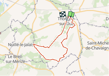
Trail Walking of 13.5 km to be discovered at Pays de la Loire, Sarthe, Thorigné-sur-Dué. This trail is proposed by Manoto.

Description

Départ : Place de l'église
Balisage : Jaune

Elevation profile

Positioning

Country:
France
Region :
Pays de la Loire
Department/Province :
Sarthe
Municipality :
Thorigné-sur-Dué
Location:
Unknown
Start:(UTM)
316181 ; 5323373 (31U) N.

Trails nearby

Trail Walking Dollon - Dollon - Semur en Vallon - Lavaré - Nostalgie des Années 30... - Photo
Walking
tracegps

Walking

Difficult
Dollon, Pays de la Loire, Sarthe, France
22 km | 26 km-effort
5h 0min
Yes
Trail Walking Thorigné-sur-Dué - Thorigné sur Dué - A l'ombre des haies 14km - Photo
Walking
tracegps

Walking

Medium
Thorigné-sur-Dué, Pays de la Loire, Sarthe, France
13.5 km | 15.7 km-effort
3h 30min
Yes
Trail Walking Thorigné-sur-Dué - Thorigné sur Dué - A l'ombre des haies, variante les Trois Chênes - Photo
Walking
tracegps

Walking

Medium
Thorigné-sur-Dué, Pays de la Loire, Sarthe, France
8.3 km | 9.8 km-effort
2h 0min
Yes
Trail Walking Thorigné-sur-Dué - Thorigné sur Dué - A l'ombre des haies, variante La Pagerie - Photo
Walking
tracegps

Walking

Easy
Thorigné-sur-Dué, Pays de la Loire, Sarthe, France
5 km | 5.8 km-effort
1h 15min
Yes
Trail Walking Saint-Michel-de-Chavaignes - st Michel de chavaigne - Photo
Walking
darkpapa

Walking

Difficult
Saint-Michel-de-Chavaignes, Pays de la Loire, Sarthe, France
12.6 km | 15.2 km-effort
2h 55min
Yes
Trail Running Le Breil-sur-Mérize - Thorigne autour de la route des haies - Photo
Running
herve.cherubin@sfr.fr

Running

Very easy
Le Breil-sur-Mérize, Pays de la Loire, Sarthe, France
21 km | 25 km-effort
3h 8min
Yes
Trail Walking Dollon - Dollon - Photo
Walking
Manoto

Walking

Very easy
Dollon, Pays de la Loire, Sarthe, France
12.1 km | 15.1 km-effort
Unknown
Yes
Trail sport Connerré - CIRCUIT VÉLO N°9 LE BERCEAU DES RILLETTES DU PERCHE SARTHOIS 44km - Photo
sport
JosVaessen

sport

Very easy
Connerré, Pays de la Loire, Sarthe, France
43 km | 49 km-effort
Unknown
Yes
Trail Cycle Saint-Michel-de-Chavaignes - La Fenderie 40 km - Photo
Cycle
jweinhard

Cycle

Very easy
Saint-Michel-de-Chavaignes, Pays de la Loire, Sarthe, France
39 km | 46 km-effort
Unknown
Yes


Close
My subscriptions