Trail Other activity Crans-Montana - Le Valais par l''Adret - Etape 6/6 - Photo

Le Valais par l''Adret - Etape 6/6

 Romrando
Romrando

User

© OpenStreetMap contributors
Length
Length
19.8 km
Max alt
Max alt
2413 m
Uphill gradient
Uphill gradient
799 m
Km-Effort
Km-Effort  
33 km
Min alt
Min alt
1368 m
Downhill gradient
Downhill gradient
1610 m
Boucle
Boucle
No
Creation date :
2014-12-11 00:00:00.0
Updated on :
2014-12-11 00:00:00.0

(0 Reviews)

Other activity
Other activity
--
Difficulty : Unknown

Scan this QR Code to open this trail in the SityTrail application

FREE GPS app for hiking

Logo SityTrail SityTrail

IGN / Geographical institutes

Download SityTrail from the App Store Download SityTrail from Google Play

Logo SityTrail SityTrail World

The world is yours!

Download SityTrail from the App Store Download SityTrail from Google Play Download SityTrail on Huawei AppGallery

About

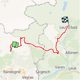
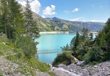
Trail Other activity of 19.8 km to be discovered at Valais/Wallis, Sierre, Crans-Montana. This trail is proposed by Romrando.

Description

Source:geocities.com/romrando

Etape 6

Cabane des Violettes (Montana) - Loèche-les-Bains


Variante a) Sous la cabane, côté E, suivre un chemin qui descend dans le vallon de la Bovèrèche et franchit ce torrent sur un pont (P. 1''938 m). De là, un autre chemin, presque horizontal, conduit par Prabaron au Bisse de Tsittoret que l''on suit jusqu''à Tièche par un agréable chemin. -->

Variante b) De la cabane des Violettes, un sentier balisé conduit vers le N puis franchit en descente une barre rocheuse. De là un chemin remonte et traverse toute la combe que domine le "Tubang" en empruntant un moment la large piste de ski. On poursuit toujours en légère montée la traversée jusqu''à la station supérieure du télécabine du Petit Mont Bonvin.

On s''engage alors vers le N dans la combe de Tièche à travers les éboulis puis on descend tout le vallon en laissant à sa gauche une grande cascade pour finir par longer la rive droite d''une gorge (main courante) qui nous conduit à un pont (poteau indicateur), source du bisse de Tsittoret, point commun de la variante a) -->

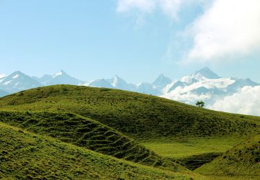
Suite commune --> On aborde alors une longue traversée ascendante à travers les mélèzes qui nous mène à l''alpe de Varneralp. On atteint un vaste plateau herbeux puis à flanc de montagne on atteint le bélvèdère de Plammis (croix - 2''146 m).

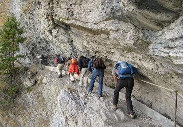
Le chemin s''engage vers le SE dans une descente qui nous conduit à un petit alpage puis à une chapelle. Quelques mètres plus bas on bifurque plein nord pour aborder puis traverser en descente la grande barre rocheuse (passage équipé et sans difficultés) qui donne accès à la vallée de Loèche-les-Bains. De là un long chemin mène à destination.

Elevation profile

Positioning

Country:
Switzerland
Region :
Valais/Wallis
Department/Province :
Sierre
Municipality :
Crans-Montana
Location:
Randogne
Start:(UTM)
384577 ; 5133177 (32T) N.

Trails nearby

Trail Walking Crans-Montana - Sentier de Huiton - Photo
Walking
GUIDE+

Walking

Very easy
(2)
Crans-Montana, Valais/Wallis, Sierre, Switzerland
7.1 km | 10.9 km-effort
2h 17min
No
Trail Mountain bike Crans-Montana - Tour des villages - Photo
Mountain bike
GUIDE+

Mountain bike

Very easy
(1)
Crans-Montana, Valais/Wallis, Sierre, Switzerland
23 km | 35 km-effort
3h 0min
Yes
Trail On foot Crans-Montana - Montagne du Plan - Trubelstock - Photo
On foot
PRO

On foot

Easy
Crans-Montana, Valais/Wallis, Sierre, Switzerland
3.8 km | 12.5 km-effort
2h 50min
No
Trail On foot Lens - Cran - Er de Chermignon (Ancien bisse du Ro) - Photo
On foot
PRO

On foot

Easy
Lens, Valais/Wallis, Sierre, Switzerland
6.1 km | 11.5 km-effort
2h 37min
No
Trail On foot Icogne - Pra du taillour-Pas de l'ours - Photo
On foot
PRO

On foot

Easy
Icogne, Valais/Wallis, Sierre, Switzerland
4 km | 7.6 km-effort
1h 42min
No
Trail On foot Icogne - Er de Chermignon-Pra du Taillour - Photo
On foot
PRO

On foot

Easy
Icogne, Valais/Wallis, Sierre, Switzerland
6.4 km | 10.2 km-effort
2h 19min
No
Trail On foot Crans-Montana - Plaine Morte-Les Violettes - Photo
On foot
PRO

On foot

Easy
Crans-Montana, Valais/Wallis, Sierre, Switzerland
4.5 km | 11.5 km-effort
2h 36min
No
Trail Mountain bike Crans-Montana - Tour Hauts de Crans - Photo
Mountain bike
GUIDE+

Mountain bike

Very easy
Crans-Montana, Valais/Wallis, Sierre, Switzerland
7.8 km | 11.3 km-effort
1h 30min
Yes
Trail Walking Noble-Contrée - Bisse Neuf and Bisse de Varen - Photo
Walking
GUIDE+

Walking

Very easy
Noble-Contrée, Valais/Wallis, Sierre, Switzerland
10.5 km | 14.8 km-effort
3h 35min
No


Close
My subscriptions