Trail Mountain bike Chaville - a VTT roulant - Photo
 mrioux
mrioux

User

© OpenStreetMap contributors
Length
Length
22 km
Max alt
Max alt
188 m
Uphill gradient
Uphill gradient
280 m
Km-Effort
Km-Effort  
25 km
Min alt
Min alt
97 m
Downhill gradient
Downhill gradient
280 m
Boucle
Boucle
Yes
Creation date :
2016-12-29 00:00:00.0
Updated on :
2016-12-29 00:00:00.0

(0 Reviews)

Mountain bike
Mountain bike
1h41
Difficulty : Easy

Scan this QR Code to open this trail in the SityTrail application

FREE GPS app for hiking

Logo SityTrail SityTrail

IGN / Geographical institutes

Download SityTrail from the App Store Download SityTrail from Google Play

Logo SityTrail SityTrail World

The world is yours!

Download SityTrail from the App Store Download SityTrail from Google Play Download SityTrail on Huawei AppGallery

About

Trail Mountain bike of 22 km to be discovered at Ile-de-France, Hauts-de-Seine, Chaville. This trail is proposed by mrioux.

Description

Petit circuit de VTT très roulant, chemin et route pas vraiment du VTT. La seul difficulté, un peu de dénivelé au début ! Superbe descente entre la N12 et la D56 !

Elevation profile

Points of interest

Point of interest Viroflay - Fin de la descente - Photo
mrioux

Positioning

Country:
France
Region :
Ile-de-France
Department/Province :
Hauts-de-Seine
Municipality :
Chaville
Location:
Unknown
Start:(UTM)
440295 ; 5405596 (31U) N.

Trails nearby

Trail Walking Chaville - Le Sentier des 7 étangs - Photo
Walking
tracegps

Walking

Difficult
(5)
Chaville, Ile-de-France, Hauts-de-Seine, France
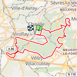
23 km | 31 km-effort
5h 0min
Yes
Trail Walking Verrières-le-Buisson - Sur les sentiers de découverte du Bois de Verrières - Photo
Walking
tracegps

Walking

Medium
(2)
Verrières-le-Buisson, Ile-de-France, Essonne, France
22 km | 27 km-effort
4h 40min
Yes
Trail Walking Viroflay - Les 3 Forêts; Meudon, Fausses Reposes et Versailles - Photo
Walking
tracegps

Walking

Difficult
(2)
Viroflay, Ile-de-France, Yvelines, France
25 km | 32 km-effort
5h 19min
Yes
Trail Walking Chaville - Sentier des deux Forêts - Meudon et Verrières - Photo
Walking
tracegps

Walking

Difficult
(2)
Chaville, Ile-de-France, Hauts-de-Seine, France
23 km | 29 km-effort
5h 0min
Yes
Trail Walking Buc - Le Tour de Satory - Photo
Walking
tracegps

Walking

Difficult
(2)
Buc, Ile-de-France, Yvelines, France
23 km | 28 km-effort
4h 49min
Yes
Trail Walking Boulogne-Billancourt - Parc de St Cloud et forêt de Fausses Reposes - Photo
Walking
tracegps

Walking

Medium
(1)
Boulogne-Billancourt, Ile-de-France, Hauts-de-Seine, France
18.2 km | 23 km-effort
4h 30min
No
Trail Walking Clamart - Tour des etangs - Bois de Clamart et de Meudon - Photo
Walking
GUIDE
affinetataille

Walking

Easy
Clamart, Ile-de-France, Hauts-de-Seine, France
8 km | 9.9 km-effort
2h 16min
Yes
Trail Other activity Versailles - Parc de Versailles - Photo
Other activity
irokoitennis

Other activity

Very easy
(1)
Versailles, Ile-de-France, Yvelines, France
8.9 km | 9.7 km-effort
1h 49min
Yes
Trail Cycle Chaville - chaville - maison lafitte - Photo
Cycle
Letizia

Cycle

Medium
(1)
Chaville, Ile-de-France, Hauts-de-Seine, France
44 km | 50 km-effort
3h 27min
No


Close
My subscriptions