Trail Mountain bike Plombières-lès-Dijon - rando plombières  - Photo
 phil21
phil21

User

© OpenStreetMap contributors
Length
Length
43 km
Max alt
Max alt
520 m
Uphill gradient
Uphill gradient
909 m
Km-Effort
Km-Effort  
55 km
Min alt
Min alt
246 m
Downhill gradient
Downhill gradient
909 m
Boucle
Boucle
No
Creation date :
2014-12-10 00:00:00.0
Updated on :
2014-12-10 00:00:00.0

(1 Reviews)

Mountain bike
Mountain bike
3h39
Difficulty : Medium

Scan this QR Code to open this trail in the SityTrail application

FREE GPS app for hiking

Logo SityTrail SityTrail

IGN / Geographical institutes

Download SityTrail from the App Store Download SityTrail from Google Play

Logo SityTrail SityTrail World

The world is yours!

Download SityTrail from the App Store Download SityTrail from Google Play Download SityTrail on Huawei AppGallery

About

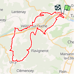
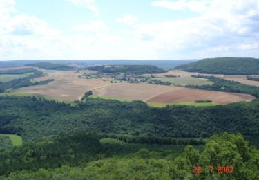
Trail Mountain bike of 43 km to be discovered at Bourgogne-Franche-Comté, Côte-d'Or, Plombières-lès-Dijon. This trail is proposed by phil21.

Elevation profile

Positioning

Country:
France
Region :
Bourgogne-Franche-Comté
Department/Province :
Côte-d'Or
Municipality :
Plombières-lès-Dijon
Location:
Unknown
Start:(UTM)
649134 ; 5244581 (31T) N.

Comments

Please log in to post a review or rate the element


Qlq problème de tracé mais très beau parcours et diversifié de surcroît Merci pour cette découverte


Trails nearby

Trail Walking Dijon - Parcours Félix Batier - Dijon - Nuits Saint Georges - Photo
Walking
tracegps

Walking

Very difficult
(6)
Dijon, Bourgogne-Franche-Comté, Côte-d'Or, France
51 km | 75 km-effort
14h 0min
No
Trail Walking Dijon - Combe St Joseph 21km Prj P8 MC 20220928 - Photo
Walking
cmike39

Walking

Very easy
(1)
Dijon, Bourgogne-Franche-Comté, Côte-d'Or, France
21 km | 29 km-effort
3h 34min
Yes
Trail Walking Velars-sur-Ouche - velars - Photo
Walking
hueco

Walking

Medium
(1)
Velars-sur-Ouche, Bourgogne-Franche-Comté, Côte-d'Or, France
13.5 km | 19.2 km-effort
3h 30min
Yes
Trail Walking Hauteville-lès-Dijon - Ballade rapide au sud d'Hauteville - Photo
Walking
yew

Walking

Very easy
(2)
Hauteville-lès-Dijon, Bourgogne-Franche-Comté, Côte-d'Or, France
4.9 km | 6.3 km-effort
59min
Yes
Trail Walking Velars-sur-Ouche - Parcours Jean Sage - Velars sur Ouche - Photo
Walking
tracegps

Walking

Difficult
(1)
Velars-sur-Ouche, Bourgogne-Franche-Comté, Côte-d'Or, France
26 km | 45 km-effort
8h 0min
No
Trail On foot Corcelles-les-Monts - Circuit découverte des Cadoles - Photo
On foot
PRO

On foot

Easy
Corcelles-les-Monts, Bourgogne-Franche-Comté, Côte-d'Or, France
3.3 km | 4 km-effort
53min
Yes
Trail On foot Dijon - Circuit Découverte des Hauts de la Combe - Photo
On foot
PRO

On foot

Easy
Dijon, Bourgogne-Franche-Comté, Côte-d'Or, France
4.2 km | 5.4 km-effort
1h 13min
Yes
Trail On foot Hauteville-lès-Dijon - Du Fort de Hauteville au Plain Saint-Laurent - Photo
On foot
PRO

On foot

Easy
Hauteville-lès-Dijon, Bourgogne-Franche-Comté, Côte-d'Or, France
7.6 km | 9.3 km-effort
2h 7min
Yes
Trail Hybrid bike Dijon - Canal de Bourgogne Dijon Buffon 146km - Photo
Hybrid bike
GUIDE
thonyc

Hybrid bike

Medium
Dijon, Bourgogne-Franche-Comté, Côte-d'Or, France
146 km | 160 km-effort
10h 0min
No


Close
My subscriptions