Trail Mountain bike Fontvieille - Fontvielle25/11/2012 9:56 - Photo
 gloeren
gloeren

User

© OpenStreetMap contributors
Length
Length
22 km
Max alt
Max alt
156 m
Uphill gradient
Uphill gradient
379 m
Km-Effort
Km-Effort  
27 km
Min alt
Min alt
28 m
Downhill gradient
Downhill gradient
381 m
Boucle
Boucle
Yes
Creation date :
2014-12-10 00:00:00.0
Updated on :
2014-12-10 00:00:00.0

(0 Reviews)

Mountain bike
Mountain bike
1h46
Difficulty : Easy

Scan this QR Code to open this trail in the SityTrail application

FREE GPS app for hiking

Logo SityTrail SityTrail

IGN / Geographical institutes

Download SityTrail from the App Store Download SityTrail from Google Play

Logo SityTrail SityTrail World

The world is yours!

Download SityTrail from the App Store Download SityTrail from Google Play Download SityTrail on Huawei AppGallery

About

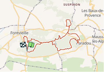
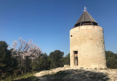
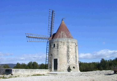
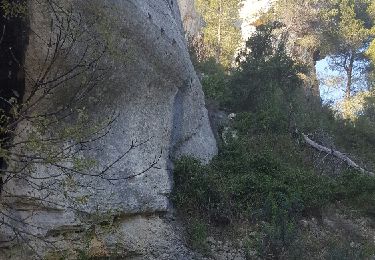
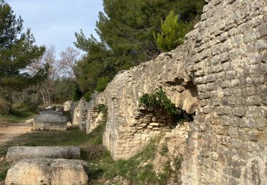
Trail Mountain bike of 22 km to be discovered at Provence-Alpes-Côte d'Azur, Bouches-du-Rhône, Fontvieille. This trail is proposed by gloeren.

Description

Départ du DFCI avant Fontvielle, puis direction Fontvielle, puis passage alentour de paradou et retour au DFCI.

Elevation profile

Positioning

Country:
France
Region :
Provence-Alpes-Côte d'Azur
Department/Province :
Bouches-du-Rhône
Municipality :
Fontvieille
Location:
Unknown
Start:(UTM)
638359 ; 4841166 (31T) N.

Trails nearby

Trail Walking Fontvieille - du moulin de Daudet à l'aqueduc romain - Photo
Walking
hervef13300

Walking

Medium
(2)
Fontvieille, Provence-Alpes-Côte d'Azur, Bouches-du-Rhône, France
14.2 km | 17.2 km-effort
3h 59min
Yes
Trail Walking Fontvieille - Fontvieille sur les pas de Daudet  - Photo
Walking
tracegps

Walking

Medium
(3)
Fontvieille, Provence-Alpes-Côte d'Azur, Bouches-du-Rhône, France
12.8 km | 15.3 km-effort
2h 34min
Yes
Trail Walking Fontvieille - Fontvieille circuit bleu - Photo
Walking
didier.zimmermann

Walking

Very easy
(1)
Fontvieille, Provence-Alpes-Côte d'Azur, Bouches-du-Rhône, France
10.4 km | 12.7 km-effort
2h 46min
Yes
Trail Walking Fontvieille - le moulin de Daudet - Photo
Walking
GUIDE
amiral13

Walking

Very easy
Fontvieille, Provence-Alpes-Côte d'Azur, Bouches-du-Rhône, France
11 km | 13.4 km-effort
3h 43min
Yes
Trail Horseback riding Fontvieille - 2019-04-28 Rando CVA Alpilles Les Enganes La Sarriette - Photo
Horseback riding
GUIDE
holtzv

Horseback riding

Difficult
Fontvieille, Provence-Alpes-Côte d'Azur, Bouches-du-Rhône, France
37 km | 45 km-effort
5h 10min
No
Trail On foot Fontvieille - Les moulins et l'aqueduc romain - Photo
On foot
morthy25

On foot

Easy
Fontvieille, Provence-Alpes-Côte d'Azur, Bouches-du-Rhône, France
8.6 km | 10.2 km-effort
2h 20min
Yes
Trail On foot Fontvieille - PF-Fontvieille et son histoire - Photo
On foot
MicDul

On foot

Very easy
Fontvieille, Provence-Alpes-Côte d'Azur, Bouches-du-Rhône, France
12.6 km | 15.1 km-effort
Unknown
Yes
Trail Walking Tarascon - Mont Paon1 La Lèque - Photo
Walking
kephas

Walking

Medium
Tarascon, Provence-Alpes-Côte d'Azur, Bouches-du-Rhône, France
13.4 km | 18.2 km-effort
3h 48min
Yes
Trail Walking Fontvieille - Les moulins de fontvieille - Photo
Walking
kayamb

Walking

Easy
Fontvieille, Provence-Alpes-Côte d'Azur, Bouches-du-Rhône, France
10.7 km | 13.1 km-effort
3h 5min
No


Close
My subscriptions