Trail Walking Morgex - Lac d'Arpy - Photo
 Alfredy
Alfredy

User

© OpenStreetMap contributors
Length
Length
10.3 km
Max alt
Max alt
2079 m
Uphill gradient
Uphill gradient
423 m
Km-Effort
Km-Effort  
15.9 km
Min alt
Min alt
1680 m
Downhill gradient
Downhill gradient
417 m
Boucle
Boucle
Yes
Creation date :
2018-08-01 12:15:35.705
Updated on :
2018-08-01 12:16:32.862

(1 Reviews)

Walking
Walking
3h17
Difficulty : Difficult

Scan this QR Code to open this trail in the SityTrail application

FREE GPS app for hiking

Logo SityTrail SityTrail

IGN / Geographical institutes

Download SityTrail from the App Store Download SityTrail from Google Play

Logo SityTrail SityTrail World

The world is yours!

Download SityTrail from the App Store Download SityTrail from Google Play Download SityTrail on Huawei AppGallery

About

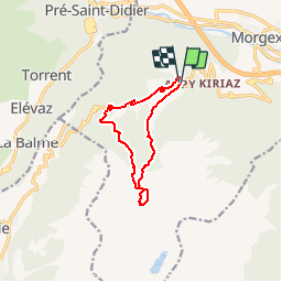
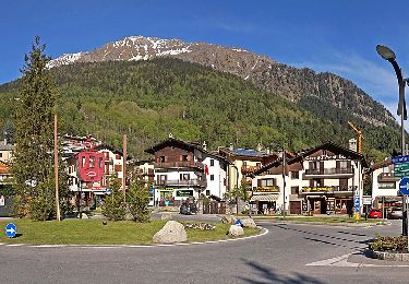
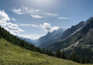
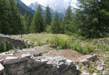
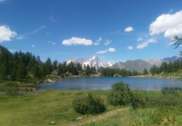
Trail Walking of 10.3 km to be discovered at Aosta Valley, Unknown, Morgex. This trail is proposed by Alfredy.

Description

Lac d'Arpy version facile - un seul Lac - 3h17

Elevation profile

Positioning

Country:
Italy
Region :
Aosta Valley
Department/Province :
Unknown
Municipality :
Morgex
Location:
Unknown
Start:(UTM)
345337 ; 5067957 (32T) N.

Comments

Please log in to post a review or rate the element


Trails nearby

Trail On foot La Thuile - Alta Via n. 2 della Valle d'Aosta - Tappa 3 - Photo
On foot
PRO

On foot

Easy
La Thuile, Aosta Valley, Unknown, Italy
8.9 km | 19.8 km-effort
4h 30min
No
Trail On foot Courmayeur - Alta Via n. 2 della Valle d'Aosta - Tappa 1 - Photo
On foot
PRO

On foot

Difficult
Courmayeur, Aosta Valley, Unknown, Italy
15.2 km | 32 km-effort
7h 15min
No
Trail On foot Courmayeur - (SI F08) Courmayeur - Rifugio Bonatti - Photo
On foot
PRO

On foot

Medium
Courmayeur, Aosta Valley, Unknown, Italy
11.9 km | 24 km-effort
5h 22min
No
Trail On foot Morgex - Itinerario 16 Col San Carlo Colle Della Croce - Photo
On foot
PRO

On foot

Easy
Morgex, Aosta Valley, Unknown, Italy
5.4 km | 6.9 km-effort
1h 34min
No
Trail Walking Morgex - arpy . lac d arpy . arpy 2h50 - Photo
Walking
stef789

Walking

Very easy
Morgex, Aosta Valley, Unknown, Italy
10.3 km | 16.1 km-effort
3h 36min
Yes
Trail Walking Courmayeur - TMB 05 - Courmayeur -> Arnouva (chalet du Val Ferret) - Photo
Walking
uru2010

Walking

Difficult
Courmayeur, Aosta Valley, Unknown, Italy
17.6 km | 32 km-effort
6h 59min
No
Trail Walking Morgex - Lac d'Arpy et le lac Di Pietra Rossa... - Photo
Walking
Alfredy

Walking

Very difficult
Morgex, Aosta Valley, Unknown, Italy
15.3 km | 28 km-effort
5h 37min
Yes
Trail Walking Morgex - Lago d'Arpy, Colle San Carlo - Photo
Walking
steph.sulon

Walking

Very easy
Morgex, Aosta Valley, Unknown, Italy
7.5 km | 9.8 km-effort
2h 23min
Yes
Trail Nordic walking Pré-Saint-Didier -   Becca Di Nonna - Photo
Nordic walking
paul74

Nordic walking

Easy
Pré-Saint-Didier, Aosta Valley, Unknown, Italy
12.3 km | 22 km-effort
7h 54min
Yes


Close
My subscriptions