Trail Walking Roquebrune-sur-Argens - z les 3 lacs 25-09-18 - Photo
 cb8310
cb8310

User

© OpenStreetMap contributors
Length
Length
6.6 km
Max alt
Max alt
86 m
Uphill gradient
Uphill gradient
95 m
Km-Effort
Km-Effort  
7.9 km
Min alt
Min alt
32 m
Downhill gradient
Downhill gradient
93 m
Boucle
Boucle
Yes
Creation date :
2018-09-25 11:59:25.615
Updated on :
2018-09-26 06:51:16.802

(0 Reviews)

Walking
Walking
2h39
Difficulty : Easy

Scan this QR Code to open this trail in the SityTrail application

FREE GPS app for hiking

Logo SityTrail SityTrail

IGN / Geographical institutes

Download SityTrail from the App Store Download SityTrail from Google Play

Logo SityTrail SityTrail World

The world is yours!

Download SityTrail from the App Store Download SityTrail from Google Play Download SityTrail on Huawei AppGallery

About

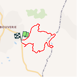
Trail Walking of 6.6 km to be discovered at Provence-Alpes-Côte d'Azur, Var, Roquebrune-sur-Argens. This trail is proposed by cb8310.

Description

rando sans difficulté particulière,si ce n'est,en descente le dernier sentier très pentu et caillouteux

Elevation profile

Photos

Positioning

Country:
France
Region :
Provence-Alpes-Côte d'Azur
Department/Province :
Var
Municipality :
Roquebrune-sur-Argens
Location:
Unknown
Start:(UTM)
310293 ; 4818469 (32T) N.

Trails nearby

Trail Walking Le Muy - les grottes Baume Renaude - Photo
Walking
boulinevelyne

Walking

Difficult
(1)
Le Muy, Provence-Alpes-Côte d'Azur, Var, France
13.3 km | 18.3 km-effort
5h 13min
No
Trail Mountain bike Puget-sur-Argens - Forêt de la Colle du Rouet aux Gorges de Blavet - Fréjus - Photo
Mountain bike
tracegps

Mountain bike

Difficult
(1)
Puget-sur-Argens, Provence-Alpes-Côte d'Azur, Var, France
23 km | 28 km-effort
3h 0min
Yes
Trail Walking Bagnols-en-Forêt - La Colle du Rouet par le Castel Diaou - Le Muy - Photo
Walking
tracegps

Walking

Difficult
(2)
Bagnols-en-Forêt, Provence-Alpes-Côte d'Azur, Var, France
18.2 km | 27 km-effort
6h 0min
Yes
Trail On foot Puget-sur-Argens - PUGET SUR ARGENS- gazoduc-Terres Gastes DRI - Photo
On foot
ripoll dominique

On foot

Easy
(1)
Puget-sur-Argens, Provence-Alpes-Côte d'Azur, Var, France
7.7 km | 8.9 km-effort
2h 1min
Yes
Trail Nordic walking Puget-sur-Argens - La Tranchée - Terre Gastes - Les Suviéres -   IBP 37 Bleu (241) - Photo
Nordic walking
ChicanneMaryse

Nordic walking

Easy
(1)
Puget-sur-Argens, Provence-Alpes-Côte d'Azur, Var, France
10.2 km | 11.6 km-effort
Unknown
Yes
Trail On foot Bagnols-en-Forêt - BAGNOLS EN FORET- Bois du défens DRI - Photo
On foot

On foot

Easy
(2)
Bagnols-en-Forêt, Provence-Alpes-Côte d'Azur, Var, France
9.3 km | 12.7 km-effort
2h 52min
Yes
Trail Walking Bagnols-en-Forêt - Gorges du Blavet au col de la pierre du coucou - Photo
Walking
GUIDE
nadinebondoux

Walking

Difficult
Bagnols-en-Forêt, Provence-Alpes-Côte d'Azur, Var, France
15.8 km | 22 km-effort
4h 44min
Yes
Trail On foot Roquebrune-sur-Argens - 2024-03-12_16h48m05_Randonn_e-44 - Photo
On foot
marsouin 83

On foot

Easy
(1)
Roquebrune-sur-Argens, Provence-Alpes-Côte d'Azur, Var, France
11.6 km | 16.2 km-effort
3h 41min
Yes
Trail Walking Le Muy - z le trou de la Jarre 12-03-24 - Photo
Walking
cb8310

Walking

Easy
Le Muy, Provence-Alpes-Côte d'Azur, Var, France
7.3 km | 8.3 km-effort
2h 32min
Yes


Close
My subscriptions