Trail Walking Baiersbronn - Ruhestein Wildsee Darmstädter Hütte - Photo

Ruhestein Wildsee Darmstädter Hütte

© OpenStreetMap contributors
Length
Length
10.6 km
Max alt
Max alt
1041 m
Uphill gradient
Uphill gradient
318 m
Km-Effort
Km-Effort  
14.8 km
Min alt
Min alt
896 m
Downhill gradient
Downhill gradient
316 m
Boucle
Boucle
Yes
Creation date :
2014-12-10 00:00:00.0
Updated on :
2014-12-10 00:00:00.0

(0 Reviews)

Walking
Walking
3h03
Difficulty : Difficult

Scan this QR Code to open this trail in the SityTrail application

FREE GPS app for hiking

Logo SityTrail SityTrail

IGN / Geographical institutes

Download SityTrail from the App Store Download SityTrail from Google Play

Logo SityTrail SityTrail World

The world is yours!

Download SityTrail from the App Store Download SityTrail from Google Play Download SityTrail on Huawei AppGallery

About

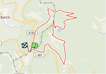
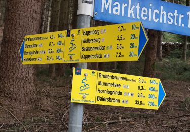
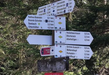
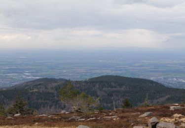
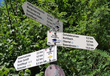
Trail Walking of 10.6 km to be discovered at Baden-Württemberg, Landkreis Freudenstadt, Baiersbronn. This trail is proposed by pjjrevrard.

Description

Variante courte de la rando vers le Wildsee (petit lac glaciaire).  Le tronçon entre les points A et B est peu fréquenté et peu visible.  Le tronçon entre C et D est dangereux (sentier à forte pente et passages dangereux).  La variante proposée sur ce site est plus longue mais beaucoup plus confortable.

Elevation profile

Points of interest

Point of interest Baiersbronn - A - Photo
pjjrevrard
BAIERSBRONN 
Point of interest Baiersbronn - B - Photo
pjjrevrard
BAIERSBRONN 
Point of interest Baiersbronn - C - Photo
pjjrevrard
BAIERSBRONN 
Point of interest Baiersbronn - D - Photo
pjjrevrard
BAIERSBRONN 

Positioning

Country:
Germany
Region :
Baden-Württemberg
Department/Province :
Landkreis Freudenstadt
Municipality :
Baiersbronn
Location:
Unknown
Start:(UTM)
442655 ; 5378961 (32U) N.

Trails nearby

Trail On foot Sasbachwalden - Hinterer Wasen - Breitenbrunnen - bequemer Weg - Photo
On foot
PRO

On foot

Easy
Sasbachwalden, Baden-Württemberg, Ortenaukreis, Germany
4.2 km | 6 km-effort
1h 21min
No
Trail On foot Seebach - Genießerpfad - Bosensteiner Almpfad - Photo
On foot
PRO

On foot

Easy
Seebach, Baden-Württemberg, Ortenaukreis, Germany
8.5 km | 12.7 km-effort
2h 53min
Yes
Trail On foot Seebach - Genießerpfad - Mummelsee-Hornisgrindepfad - Photo
On foot
PRO

On foot

Easy
Seebach, Baden-Württemberg, Ortenaukreis, Germany
6.5 km | 10.2 km-effort
2h 18min
Yes
Trail On foot Baiersbronn - Schöner Platz-Hänger - Photo
On foot
PRO

On foot

Easy
Baiersbronn, Baden-Württemberg, Landkreis Freudenstadt, Germany
5.9 km | 7.4 km-effort
1h 40min
No
Trail On foot Baiersbronn - Obertal - Ruhestein - Photo
On foot
PRO

On foot

Easy
Baiersbronn, Baden-Württemberg, Landkreis Freudenstadt, Germany
7 km | 10.3 km-effort
2h 20min
No
Trail On foot Baiersbronn - Obertal - Zuflucht - Photo
On foot
PRO

On foot

Easy
Baiersbronn, Baden-Württemberg, Landkreis Freudenstadt, Germany
6.8 km | 11.1 km-effort
2h 30min
No
Trail Walking Oppenau - allerheiligen  - Photo
Walking
apa

Walking

Easy
Oppenau, Baden-Württemberg, Ortenaukreis, Germany
3.6 km | 5.8 km-effort
2h 41min
Yes
Trail Walking Seebach - mummelsee - grindehutte - Photo
Walking
mitch1915

Walking

Medium
Seebach, Baden-Württemberg, Ortenaukreis, Germany
8.7 km | 11.9 km-effort
4h 7min
No
Trail On foot Baiersbronn - Terrainkurweg - Photo
On foot
PRO

On foot

Easy
Baiersbronn, Baden-Württemberg, Landkreis Freudenstadt, Germany
5.2 km | 6.4 km-effort
1h 27min
No


Close
My subscriptions