Trail Walking Besse-et-Saint-Anastaise - Tracé actuel: 23 MARS 2019 12:57 - Photo
 GilGry
GilGry

User

© OpenStreetMap contributors
Length
Length
17.6 km
Max alt
Max alt
1398 m
Uphill gradient
Uphill gradient
487 m
Km-Effort
Km-Effort  
24 km
Min alt
Min alt
1195 m
Downhill gradient
Downhill gradient
488 m
Boucle
Boucle
Yes
Creation date :
2019-03-23 18:02:52.31
Updated on :
2019-03-25 10:03:18.273

(0 Reviews)

Walking
Walking
4h30
Difficulty : Difficult

Scan this QR Code to open this trail in the SityTrail application

FREE GPS app for hiking

Logo SityTrail SityTrail

IGN / Geographical institutes

Download SityTrail from the App Store Download SityTrail from Google Play

Logo SityTrail SityTrail World

The world is yours!

Download SityTrail from the App Store Download SityTrail from Google Play Download SityTrail on Huawei AppGallery

About

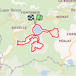
Trail Walking of 17.6 km to be discovered at Auvergne-Rhône-Alpes, Puy-de-Dôme, Besse-et-Saint-Anastaise. This trail is proposed by GilGry.

Description

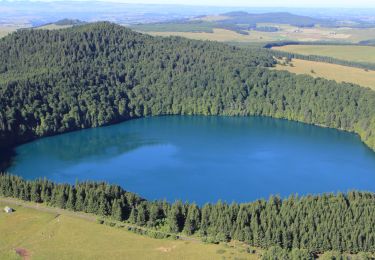
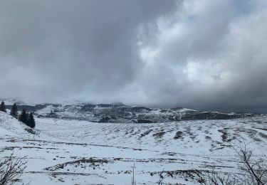
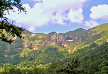
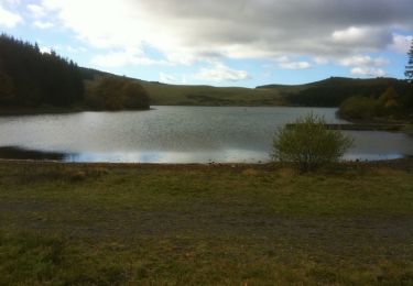
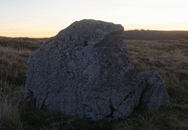
Départ du Lac Pavin. On prend un peu de hauteur direction montagne de la scepeix puis retour vers la foret des Fraux. Ascension du Puy de Montchal (1407 mètres) bon c'est pas la mer à boire. Descente puis grenouillage dans la foret de Fraux en empruntant divers pistes de ski de fond et de raquettes. Passage au creux de soucy (ca ne casse pas 3 pattes à 1 canard. Le gouffre est clôturé. Arrivée sur le flanc sud-est du lac Pavin. Le point de vue est top. Je poursuis ma pérégrination vers le lac Estivadoux, un tour dans le bois de la montagne des Fraux et une trace à travers l'estive direction un sommet. ( Histoire de ne pas reprendre le même chemin. Un peu de hors piste pour rejoindre le chemin de ronde du lac.

Elevation profile

Photos

Positioning

Country:
France
Region :
Auvergne-Rhône-Alpes
Department/Province :
Puy-de-Dôme
Municipality :
Besse-et-Saint-Anastaise
Location:
Besse
Start:(UTM)
491061 ; 5038499 (31T) N.

Trails nearby

Trail Walking Besse-et-Saint-Anastaise - Cascades de Chiloza - Photo
Walking
jome63

Walking

Medium
(2)
Besse-et-Saint-Anastaise, Auvergne-Rhône-Alpes, Puy-de-Dôme, France
4.6 km | 6.6 km-effort
1h 44min
Yes
Trail Walking Besse-et-Saint-Anastaise - Besse_Couze_Pavin_1 - Photo
Walking
GUIDE
jagarnier

Walking

Medium
(1)
Besse-et-Saint-Anastaise, Auvergne-Rhône-Alpes, Puy-de-Dôme, France
11.9 km | 16.4 km-effort
3h 30min
Yes
Trail Walking Besse-et-Saint-Anastaise - Sancy par Super-Besse - Photo
Walking
tracegps

Walking

Difficult
(1)
Besse-et-Saint-Anastaise, Auvergne-Rhône-Alpes, Puy-de-Dôme, France
10 km | 19.2 km-effort
3h 0min
Yes
Trail Walking Besse-et-Saint-Anastaise - Les 3 lacs et la cascade  - Photo
Walking
zefreefly

Walking

Easy
(1)
Besse-et-Saint-Anastaise, Auvergne-Rhône-Alpes, Puy-de-Dôme, France
19 km | 25 km-effort
7h 24min
Yes
Trail Walking Chambon-sur-Lac - Chambon_Vallee_Chaudefour_2 - Photo
Walking
GUIDE
jagarnier

Walking

Difficult
(1)
Chambon-sur-Lac, Auvergne-Rhône-Alpes, Puy-de-Dôme, France
15 km | 26 km-effort
4h 30min
Yes
Trail Mountain bike Besse-et-Saint-Anastaise - Espace VTT FFC du Sancy - Circuit n°30 - Tour des Lacs - Secteur Besse - Photo
Mountain bike
tracegps

Mountain bike

Very difficult
(1)
Besse-et-Saint-Anastaise, Auvergne-Rhône-Alpes, Puy-de-Dôme, France
29 km | 38 km-effort
2h 0min
Yes
Trail Walking Besse-et-Saint-Anastaise - Les cascades de Chiloza  - Photo
Walking
deNerval30

Walking

Easy
(1)
Besse-et-Saint-Anastaise, Auvergne-Rhône-Alpes, Puy-de-Dôme, France
4.9 km | 7 km-effort
1h 39min
Yes
Trail Walking Besse-et-Saint-Anastaise - Les trois lacs - Pavin - Montcineyre et Bourdouze - Photo
Walking
tracegps

Walking

Difficult
(1)
Besse-et-Saint-Anastaise, Auvergne-Rhône-Alpes, Puy-de-Dôme, France
19.3 km | 26 km-effort
4h 49min
Yes
Trail On foot Besse-et-Saint-Anastaise - La Chapelle de Vassivière - Photo
On foot
PRO

On foot

Easy
Besse-et-Saint-Anastaise, Auvergne-Rhône-Alpes, Puy-de-Dôme, France
11.6 km | 16.7 km-effort
3h 47min
Yes


Close
My subscriptions