Trail On foot Haute-Ajoie - autour de réclère - Photo
 cherlieu
cherlieu

User

© OpenStreetMap contributors
Length
Length
19.6 km
Max alt
Max alt
839 m
Uphill gradient
Uphill gradient
623 m
Km-Effort
Km-Effort  
28 km
Min alt
Min alt
514 m
Downhill gradient
Downhill gradient
619 m
Boucle
Boucle
Yes
Creation date :
2019-04-04 13:38:22.384
Updated on :
2019-04-04 13:40:33.984

(0 Reviews)

On foot
On foot
--
Difficulty : Difficult

Scan this QR Code to open this trail in the SityTrail application

FREE GPS app for hiking

Logo SityTrail SityTrail

IGN / Geographical institutes

Download SityTrail from the App Store Download SityTrail from Google Play

Logo SityTrail SityTrail World

The world is yours!

Download SityTrail from the App Store Download SityTrail from Google Play Download SityTrail on Huawei AppGallery

About

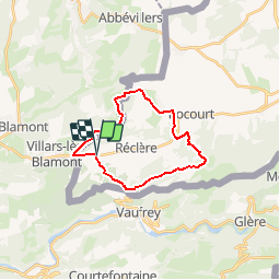
Trail On foot of 19.6 km to be discovered at Jura, District de Porrentruy, Haute-Ajoie. This trail is proposed by cherlieu.

Description

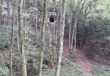
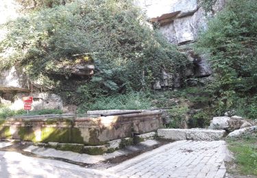
Passage par Roche d'Or (Suisse)

Elevation profile

Points of interest

Point of interest Haute-Ajoie - chalet pique nique - Photo
cherlieu
HAUTE-AJOIE 

Positioning

Country:
Switzerland
Region :
Jura
Department/Province :
District de Porrentruy
Municipality :
Haute-Ajoie
Location:
Unknown
Start:(UTM)
341281 ; 5248682 (32T) N.

Trails nearby

Trail On foot Haute-Ajoie - Tour de Faux d'Enson - fixme - Photo
On foot
PRO

On foot

Easy
Haute-Ajoie, Jura, District de Porrentruy, Switzerland
4.5 km | 6.1 km-effort
1h 22min
No
Trail On foot Haute-Ajoie - Tour de Faux d'Enson - Rocourt - Photo
On foot
PRO

On foot

Easy
Haute-Ajoie, Jura, District de Porrentruy, Switzerland
5.3 km | 7 km-effort
1h 36min
No
Trail Walking Roches-lès-Blamont - 2019.09.06.Roches  - Photo
Walking
ROPPJP

Walking

Very easy
Roches-lès-Blamont, Bourgogne-Franche-Comté, Doubs, France
11.4 km | 16.5 km-effort
3h 12min
Yes
Trail Walking Roches-lès-Blamont - 2019.09.05.Roches  - Photo
Walking
ROPPJP

Walking

Very easy
Roches-lès-Blamont, Bourgogne-Franche-Comté, Doubs, France
10.8 km | 14.7 km-effort
2h 38min
Yes
Trail Mountain bike Pierrefontaine-lès-Blamont - dans le lomont et la frontière franco suisse - Photo
Mountain bike
jibus90

Mountain bike

Difficult
Pierrefontaine-lès-Blamont, Bourgogne-Franche-Comté, Doubs, France
42 km | 59 km-effort
4h 38min
Yes
Trail On foot Haute-Ajoie - Rocourt - fixme - Photo
On foot
PRO

On foot

Easy
Haute-Ajoie, Jura, District de Porrentruy, Switzerland
4.3 km | 5.2 km-effort
1h 11min
No
Trail Walking Roches-lès-Blamont - 2019.09.04.Roches  - Photo
Walking
ROPPJP

Walking

Very easy
Roches-lès-Blamont, Bourgogne-Franche-Comté, Doubs, France
9.6 km | 12.9 km-effort
2h 31min
Yes
Trail Walking Haute-Ajoie - Circuit des fermes 26-03-17 - Photo
Walking
juliogomez

Walking

Easy
Haute-Ajoie, Jura, District de Porrentruy, Switzerland
11.6 km | 18.3 km-effort
4h 7min
Yes
Trail Walking Villars-lès-Blamont - Sappois  - Photo
Walking
juliogomez

Walking

Medium
Villars-lès-Blamont, Bourgogne-Franche-Comté, Doubs, France
15.7 km | 23 km-effort
5h 15min
Yes


Close
My subscriptions