Trail Walking Saint-Pierre-la-Palud - Col de la Luère - Mercruy - Photo
 Patxo
Patxo

User

© OpenStreetMap contributors
Length
Length
10.9 km
Max alt
Max alt
776 m
Uphill gradient
Uphill gradient
389 m
Km-Effort
Km-Effort  
16 km
Min alt
Min alt
505 m
Downhill gradient
Downhill gradient
380 m
Boucle
Boucle
Yes
Creation date :
2014-12-10 00:00:00.0
Updated on :
2014-12-10 00:00:00.0

(0 Reviews)

Walking
Walking
3h23
Difficulty : Medium

Scan this QR Code to open this trail in the SityTrail application

FREE GPS app for hiking

Logo SityTrail SityTrail

IGN / Geographical institutes

Download SityTrail from the App Store Download SityTrail from Google Play

Logo SityTrail SityTrail World

The world is yours!

Download SityTrail from the App Store Download SityTrail from Google Play Download SityTrail on Huawei AppGallery

About

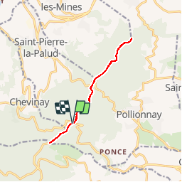
Trail Walking of 10.9 km to be discovered at Auvergne-Rhône-Alpes, Rhône, Saint-Pierre-la-Palud. This trail is proposed by Patxo.

Description

Départ du Col de la Luère vers Mercruy.

Elevation profile

Positioning

Country:
France
Region :
Auvergne-Rhône-Alpes
Department/Province :
Rhône
Municipality :
Saint-Pierre-la-Palud
Location:
Unknown
Start:(UTM)
626663 ; 5068983 (31T) N.

Trails nearby

Trail Walking Pollionnay - Pollionnay, Croix du Ban,  la Luère 7,5 Km - Photo
Walking
tracegps

Walking

Medium
(2)
Pollionnay, Auvergne-Rhône-Alpes, Rhône, France
7.3 km | 12 km-effort
2h 0min
Yes
Trail Walking Pollionnay - Pollionnay - Col de la Croix du Ban - Saint Bel - Photo
Walking
jacques delaporte

Walking

Very difficult
(1)
Pollionnay, Auvergne-Rhône-Alpes, Rhône, France
28 km | 40 km-effort
9h 9min
Yes
Trail Walking Vaugneray - Sur les hauteurs de Vaugneray - Photo
Walking
tracegps

Walking

Medium
(4)
Vaugneray, Auvergne-Rhône-Alpes, Rhône, France
12.5 km | 19.2 km-effort
4h 0min
Yes
Trail Walking Courzieu - 2023-05-11_18h58m29_Fiche Verte n°5_Courzieu - Photo
Walking
daniellebou

Walking

Difficult
(1)
Courzieu, Auvergne-Rhône-Alpes, Rhône, France
9 km | 15 km-effort
3h 23min
Yes
Trail Walking Saint-Pierre-la-Palud - Croix du ban - Col de la Luère - St Bonnet le froid - Photo
Walking
daniellebou

Walking

Difficult
(1)
Saint-Pierre-la-Palud, Auvergne-Rhône-Alpes, Rhône, France
9.6 km | 14.3 km-effort
3h 15min
Yes
Trail Walking Vaugneray - Vaugneray - Lac D'Yseron- Parc Animalier de Courzieu - Photo
Walking
jacques delaporte

Walking

Very difficult
(1)
Vaugneray, Auvergne-Rhône-Alpes, Rhône, France
38 km | 58 km-effort
13h 13min
Yes
Trail Mountain bike Vaugneray - Belle boucle!  800m sur 24kms. - Photo
Mountain bike
dup69

Mountain bike

Medium
(1)
Vaugneray, Auvergne-Rhône-Alpes, Rhône, France
25 km | 36 km-effort
3h 0min
Yes
Trail Horseback riding Sainte-Consorce - Balade en forêt  - Photo
Horseback riding
c.decqcaillet

Horseback riding

Easy
(1)
Sainte-Consorce, Auvergne-Rhône-Alpes, Rhône, France
6.5 km | 8.8 km-effort
1h 17min
Yes
Trail Mountain bike Vaugneray - VTT VAUGNERAY - Photo
Mountain bike
skwick

Mountain bike

Difficult
(1)
Vaugneray, Auvergne-Rhône-Alpes, Rhône, France
17.4 km | 26 km-effort
Unknown
Yes


Close
My subscriptions