Trail Walking Nolay - Nolay - Monts de Rème et Rome- Chateau -les trois croix - Photo

Nolay - Monts de Rème et Rome- Chateau -les trois croix

 mpstoop
mpstoop

User

© OpenStreetMap contributors
Length
Length
27 km
Max alt
Max alt
542 m
Uphill gradient
Uphill gradient
749 m
Km-Effort
Km-Effort  
37 km
Min alt
Min alt
273 m
Downhill gradient
Downhill gradient
754 m
Boucle
Boucle
Yes
Creation date :
2019-05-07 14:57:50.581
Updated on :
2019-05-28 09:04:59.59

(0 Reviews)

Walking
Walking
7h56
Difficulty : Very difficult

Scan this QR Code to open this trail in the SityTrail application

FREE GPS app for hiking

Logo SityTrail SityTrail

IGN / Geographical institutes

Download SityTrail from the App Store Download SityTrail from Google Play

Logo SityTrail SityTrail World

The world is yours!

Download SityTrail from the App Store Download SityTrail from Google Play Download SityTrail on Huawei AppGallery

About

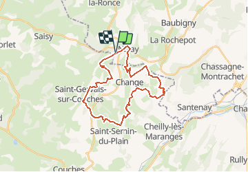
Trail Walking of 27 km to be discovered at Bourgogne-Franche-Comté, Côte-d'Or, Nolay. This trail is proposed by mpstoop.

Description

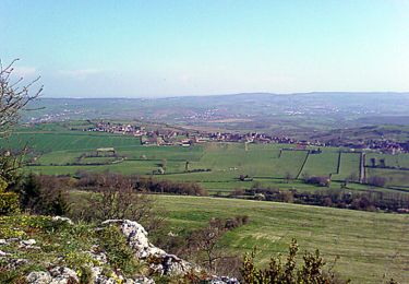
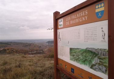
tracé aèrien et musclé incluant plusieurs points de vue à 360° entre Côte d'Or sud et Nord de Saône et Loire . Prévoir une longue journée, sans brouillard si possible car ce serait dommage !!

Elevation profile

Positioning

Country:
France
Region :
Bourgogne-Franche-Comté
Department/Province :
Côte-d'Or
Municipality :
Nolay
Location:
Unknown
Start:(UTM)
623351 ; 5200710 (31T) N.

Trails nearby

Trail Walking Nolay - Circuit Jean-Marc Boivin - Nolay - Photo
Walking
tracegps

Walking

Very difficult
(2)
Nolay, Bourgogne-Franche-Comté, Côte-d'Or, France
47 km | 67 km-effort
10h 0min
Yes
Trail Walking La Rochepot - SityTrail - 2208667 - la-rochepot-fontaine-dxorches-page-34 - Photo
Walking
jcbossant

Walking

Very difficult
(1)
La Rochepot, Bourgogne-Franche-Comté, Côte-d'Or, France
17.9 km | 26 km-effort
5h 54min
Yes
Trail On foot Cormot-Vauchignon - Tour du Bout du Monde - Photo
On foot
PRO

On foot

Easy
Cormot-Vauchignon, Bourgogne-Franche-Comté, Côte-d'Or, France
10.1 km | 13.1 km-effort
2h 58min
Yes
Trail On foot La Rochepot - Sentier des Roches - Photo
On foot
PRO

On foot

Medium
La Rochepot, Bourgogne-Franche-Comté, Côte-d'Or, France
14.1 km | 21 km-effort
4h 46min
Yes
Trail On foot Santenay - Circuit des Crêtes - Photo
On foot
PRO

On foot

Easy
Santenay, Bourgogne-Franche-Comté, Côte-d'Or, France
11 km | 16.2 km-effort
3h 40min
Yes
Trail Walking Saint-Sernin-du-Plain - Mazenay les deux monts page 17 - Photo
Walking
grasgilbert

Walking

Very difficult
(1)
Saint-Sernin-du-Plain, Bourgogne-Franche-Comté, Saône-et-Loire, France
13.5 km | 19.4 km-effort
4h 24min
Yes
Trail Walking Sampigny-lès-Maranges - Sampigny les maranges  - Photo
Walking
grasgilbert

Walking

Difficult
(4)
Sampigny-lès-Maranges, Bourgogne-Franche-Comté, Saône-et-Loire, France
12.6 km | 17 km-effort
3h 51min
Yes
Trail Walking Baubigny - Sentier des roches - Photo
Walking
micheldutilleul

Walking

Difficult
(1)
Baubigny, Bourgogne-Franche-Comté, Côte-d'Or, France
15.2 km | 22 km-effort
4h 41min
Yes
Trail Walking Nolay - Nolay - Photo
Walking
pensionisten71

Walking

Very difficult
Nolay, Bourgogne-Franche-Comté, Côte-d'Or, France
18.6 km | 27 km-effort
4h 34min
Yes


Close
My subscriptions