


Vernègues-Alleins

Berpav
User
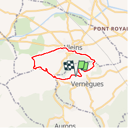

Length
10.5 km

Max alt
367 m

Uphill gradient
251 m
Km-Effort
13.9 km

Min alt
147 m

Downhill gradient
251 m
Boucle
Yes
Creation date :
2019-05-28 19:15:38.948
Updated on :
2019-05-28 19:16:40.337
2h57
Difficulty : Difficult

FREE GPS app for hiking
 SityTrail
IGN / Geographical institutes
SityTrail Plus
The world is yours!
About
Trail Walking of 10.5 km to be discovered at Provence-Alpes-Côte d'Azur, Bouches-du-Rhône, Vernègues. This trail is proposed by Berpav.
Positioning
Country:
France
Region :
Provence-Alpes-Côte d'Azur
Department/Province :
Bouches-du-Rhône
Municipality :
Vernègues
Location:
Unknown
Start:(Dec)
Start:(UTM)
674429 ; 4839680 (31T) N.
Comments
belle rando