Trail Walking Aspach-Michelbach - Tour de Michelbach 11km_wpt_trk(1) - Photo

Tour de Michelbach 11km_wpt_trk(1)

 JCLUTT
JCLUTT

User

© OpenStreetMap contributors
Length
Length
12.1 km
Max alt
Max alt
421 m
Uphill gradient
Uphill gradient
217 m
Km-Effort
Km-Effort  
15 km
Min alt
Min alt
298 m
Downhill gradient
Downhill gradient
215 m
Boucle
Boucle
Yes
Creation date :
2019-06-01 09:56:39.985
Updated on :
2021-05-26 13:01:06.437

(0 Reviews)

Walking
Walking
--
Difficulty : Easy

Scan this QR Code to open this trail in the SityTrail application

FREE GPS app for hiking

Logo SityTrail SityTrail

IGN / Geographical institutes

Download SityTrail from the App Store Download SityTrail from Google Play

Logo SityTrail SityTrail World

The world is yours!

Download SityTrail from the App Store Download SityTrail from Google Play Download SityTrail on Huawei AppGallery

About

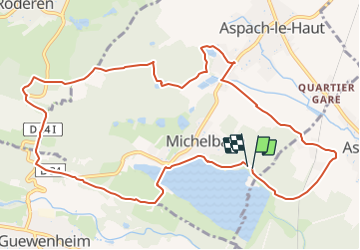
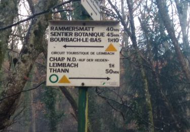
Trail Walking of 12.1 km to be discovered at Grand Est, Haut-Rhin, Aspach-Michelbach. This trail is proposed by JCLUTT.

Description

Randonnée facile à la portée de tous.

Elevation profile

Points of interest

Point of interest Aspach-Michelbach - A: Départ Parking lac - Photo
JCLUTT
ASPACH-MICHELBACH 
Point of interest Aspach-le-Bas - B: Gauche-Cercle rouge - Photo
JCLUTT
ASPACH-LE-BAS 
Point of interest Aspach-le-Bas - C: Droite-Point rouge - Photo
JCLUTT
ASPACH-LE-BAS 
Point of interest Aspach-Michelbach - D: Droite-D34 - Photo
JCLUTT
ASPACH-MICHELBACH 
Point of interest Aspach-Michelbach - E: Gauche-Village-Croix rouge - Photo
JCLUTT
Point of interest Aspach-Michelbach - F: Gauche-Croix rouge - Photo
JCLUTT
ASPACH-MICHELBACH 
Point of interest Aspach-Michelbach - G: Gauche - Photo
JCLUTT
ASPACH-MICHELBACH 
Point of interest Aspach-Michelbach - H: Nom16 - Photo
JCLUTT
ASPACH-MICHELBACH 
Point of interest Aspach-Michelbach - I: Gauche-Croix rouge - Photo
JCLUTT
ASPACH-MICHELBACH 
Point of interest Aspach-Michelbach - J: Gauche-Croix+Triangle rouge - Photo
JCLUTT
Point of interest Roderen - L: Point de vue - Photo
JCLUTT
Point of interest Aspach-Michelbach - O: Droite-Triangle bleu - Photo
JCLUTT
ASPACH-MICHELBACH 
Point of interest Aspach-Michelbach - P: Gauche-Triangle bleu - Photo
JCLUTT
ASPACH-MICHELBACH 
Point of interest Aspach-Michelbach - Q: Droite-Couronne verte - Photo
JCLUTT
ASPACH-MICHELBACH 
Point of interest Aspach-Michelbach - R: Droite - Photo
JCLUTT
ASPACH-MICHELBACH 
Point of interest Aspach-Michelbach - S: Arrivée parking - Photo
JCLUTT
ASPACH-MICHELBACH 

Positioning

Country:
France
Region :
Grand Est
Department/Province :
Haut-Rhin
Municipality :
Aspach-Michelbach
Location:
Michelbach
Start:(UTM)
359802 ; 5291354 (32T) N.

Trails nearby

Trail Walking Burnhaupt-le-Haut - Rando du 09/02/2024 par Alain...Pont d'Aspach - Photo
Walking
boubou68

Walking

Very difficult
Burnhaupt-le-Haut, Grand Est, Haut-Rhin, France
22 km | 27 km-effort
5h 12min
Yes
Trail Walking Sentheim - sentheim saegerkopf - Photo
Walking
baratta

Walking

Easy
(1)
Sentheim, Grand Est, Haut-Rhin, France
11.6 km | 15.1 km-effort
3h 14min
Yes
Trail Walking Guewenheim - Circuit de la Doller  - Photo
Walking
domi68440

Walking

Medium
Guewenheim, Grand Est, Haut-Rhin, France
10.7 km | 12.2 km-effort
2h 24min
Yes
Trail Walking Le Haut-Soultzbach - Lac de la Seigneurie (10/01/2019) - Photo
Walking
Richard68500

Walking

Easy
Le Haut-Soultzbach, Grand Est, Haut-Rhin, France
16.3 km | 19.5 km-effort
4h 24min
Yes
Trail Walking Aspach-Michelbach - Aspach le Haut (6/12/2018) - Photo
Walking
Richard68500

Walking

Medium
Aspach-Michelbach, Grand Est, Haut-Rhin, France
15 km | 19.4 km-effort
3h 34min
Yes
Trail Walking Guewenheim - Guewenheim. 68 - Photo
Walking
jeankrust

Walking

Very easy
Guewenheim, Grand Est, Haut-Rhin, France
13.1 km | 15 km-effort
3h 14min
No
Trail Walking Rammersmatt - Hundsrück (04/11/2021) - Photo
Walking
Richard68500

Walking

Medium
Rammersmatt, Grand Est, Haut-Rhin, France
10.8 km | 17.8 km-effort
3h 14min
Yes
Trail Electric bike Thann - Grand ballon 2021 - Photo
Electric bike
Derrendinger

Electric bike

Thann, Grand Est, Haut-Rhin, France
48 km | 67 km-effort
3h 31min
No
Trail Walking Roderen - Roderen - Photo
Walking
ROPPJP

Walking

Difficult
Roderen, Grand Est, Haut-Rhin, France
9.5 km | 12.2 km-effort
2h 46min
Yes


Close
My subscriptions