


AUTHON Faissal La Croix de Vey ré Sommet de Chine o

RobinMicheline
User GUIDE
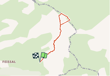

Length
6.6 km

Max alt
1939 m

Uphill gradient
537 m
Km-Effort
13.8 km

Min alt
1398 m

Downhill gradient
538 m
Boucle
Yes
Creation date :
2019-06-03 07:27:17.087
Updated on :
2019-12-22 17:13:35.296
4h50
Difficulty : Difficult

FREE GPS app for hiking
 SityTrail
IGN / Geographical institutes
SityTrail Plus
The world is yours!
About
Trail Walking of 6.6 km to be discovered at Provence-Alpes-Côte d'Azur, Alpes-de-Haute-Provence, Authon. This trail is proposed by RobinMicheline.
Description
15 kms AR en partie 600 M dénivelé à refaire
Positioning
Country:
France
Region :
Provence-Alpes-Côte d'Azur
Department/Province :
Alpes-de-Haute-Provence
Municipality :
Authon
Location:
Unknown
Start:(Dec)
Start:(UTM)
276195 ; 4902457 (32T) N.
Comments