


notre dame du cruet cohendet

lecmic
User
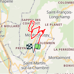

Length
15 km

Max alt
1607 m

Uphill gradient
1007 m
Km-Effort
28 km

Min alt
617 m

Downhill gradient
1006 m
Boucle
Yes
Creation date :
2019-06-06 06:11:56.564
Updated on :
2019-06-06 12:51:17.068
6h37
Difficulty : Medium

FREE GPS app for hiking
 SityTrail
IGN / Geographical institutes
SityTrail Plus
The world is yours!
About
Trail Walking of 15 km to be discovered at Auvergne-Rhône-Alpes, Savoy, Notre-Dame-du-Cruet. This trail is proposed by lecmic.
Description
randonnee en circuit
Positioning
Country:
France
Region :
Auvergne-Rhône-Alpes
Department/Province :
Savoy
Municipality :
Notre-Dame-du-Cruet
Location:
Unknown
Start:(Dec)
Start:(UTM)
289760 ; 5028258 (32T) N.
Comments