Trail Horseback riding Sousceyrac-en-Quercy - Comiac cavaliers - Photo
© OpenStreetMap contributors
Length
Length
19.4 km
Max alt
Max alt
678 m
Uphill gradient
Uphill gradient
395 m
Km-Effort
Km-Effort  
25 km
Min alt
Min alt
524 m
Downhill gradient
Downhill gradient
395 m
Boucle
Boucle
Yes
Creation date :
2019-06-09 08:23:28.0
Updated on :
2019-08-13 20:56:24.21

(0 Reviews)

Horseback riding
Horseback riding
2h45
Difficulty : Unknown

Scan this QR Code to open this trail in the SityTrail application

FREE GPS app for hiking

Logo SityTrail SityTrail

IGN / Geographical institutes

Download SityTrail from the App Store Download SityTrail from Google Play

Logo SityTrail SityTrail World

The world is yours!

Download SityTrail from the App Store Download SityTrail from Google Play Download SityTrail on Huawei AppGallery

About

Trail Horseback riding of 19.4 km to be discovered at Occitania, Lot, Sousceyrac-en-Quercy. This trail is proposed by daniel46100.

Elevation profile

Positioning

Country:
France
Region :
Occitania
Department/Province :
Lot
Municipality :
Sousceyrac-en-Quercy
Location:
Comiac
Start:(UTM)
421707 ; 4978220 (31T) N.

Trails nearby

Trail Walking Camps-Saint-Mathurin-Léobazel - Camps - Mercoeur - Photo
Walking
houbart

Walking

Difficult
(1)
Camps-Saint-Mathurin-Léobazel, New Aquitaine, Corrèze, France
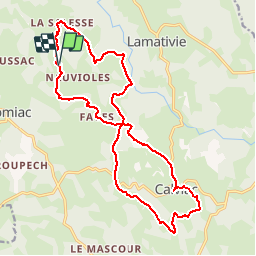
14 km | 17.5 km-effort
3h 58min
Yes
Trail Walking Camps-Saint-Mathurin-Léobazel - La Via Arverna (Camps-Saint-Mathurin - Bretenoux) - Photo
Walking
tracegps

Walking

Difficult
(1)
Camps-Saint-Mathurin-Léobazel, New Aquitaine, Corrèze, France
29 km | 39 km-effort
8h 0min
No
Trail Walking Teyssieu - Teyssieu - Photo
Walking
Gaillard Isabelle

Walking

Medium
Teyssieu, Occitania, Lot, France
17.5 km | 24 km-effort
5h 30min
Yes
Trail Walking Camps-Saint-Mathurin-Léobazel - de Camps St Mathurin à Laval de Cere - Photo
Walking
neleda

Walking

Medium
Camps-Saint-Mathurin-Léobazel, New Aquitaine, Corrèze, France
20 km | 30 km-effort
6h 37min
No
Trail Mountain bike Teyssieu - SityTrail - 4x4 gorges de la cère - Photo
Mountain bike
Gpoujade

Mountain bike

Very difficult
Teyssieu, Occitania, Lot, France
37 km | 51 km-effort
3h 31min
Yes
Trail Horseback riding Sousceyrac-en-Quercy - comiac 19 km - Photo
Horseback riding
daniel46100

Horseback riding

Medium
Sousceyrac-en-Quercy, Occitania, Lot, France
18.9 km | 25 km-effort
3h 3min
No
Trail Mountain bike Teyssieu - 4x4 Bretenoux Teyssieu - Photo
Mountain bike
alain46

Mountain bike

Very easy
Teyssieu, Occitania, Lot, France
58 km | 75 km-effort
4h 37min
No
Trail Walking Sousceyrac-en-Quercy - Calviac - Photo
Walking
caldefran

Walking

Easy
Sousceyrac-en-Quercy, Occitania, Lot, France
21 km | 28 km-effort
7h 0min
Yes
Trail Running Camps-Saint-Mathurin-Léobazel - camps_25K - Photo
Running
frederic.farge

Running

Medium
Camps-Saint-Mathurin-Léobazel, New Aquitaine, Corrèze, France
25 km | 41 km-effort
Unknown
No


Close
My subscriptions