Trail Walking Le Monêtier-les-Bains - Col de Côte Plaine - Photo
© OpenStreetMap contributors
Length
Length
3.2 km
Max alt
Max alt
2647 m
Uphill gradient
Uphill gradient
295 m
Km-Effort
Km-Effort  
7.2 km
Min alt
Min alt
2341 m
Downhill gradient
Downhill gradient
295 m
Boucle
Boucle
Yes
Creation date :
2019-06-11 07:50:45.59
Updated on :
2019-06-11 07:56:08.585

(0 Reviews)

Walking
Walking
1h24
Difficulty : Medium

Scan this QR Code to open this trail in the SityTrail application

FREE GPS app for hiking

Logo SityTrail SityTrail

IGN / Geographical institutes

Download SityTrail from the App Store Download SityTrail from Google Play

Logo SityTrail SityTrail World

The world is yours!

Download SityTrail from the App Store Download SityTrail from Google Play Download SityTrail on Huawei AppGallery

About

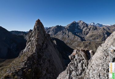
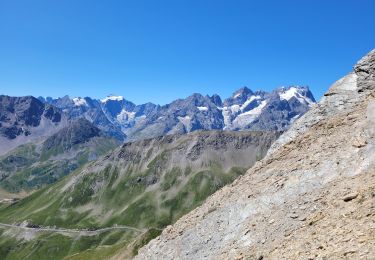
Trail Walking of 3.2 km to be discovered at Provence-Alpes-Côte d'Azur, Hautes-Alpes, Le Monêtier-les-Bains. This trail is proposed by Thomasdanielle.

Description

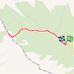
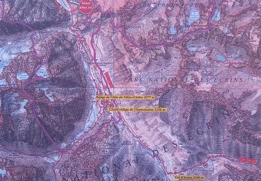
De  Monêtier-les-Bains, emprunter la Route des Grandes Alpes jusqu'au Col du Lautaret puis vers le Col du Galibier. Juste avant le troisième virage en épingle et à l'altitude de 2349m stationner sur le petit parking situé à droite de la route.

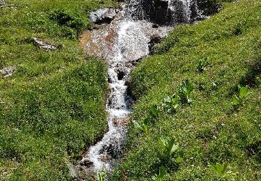
Du parking, emprunter le sentier qui part de l'épingle au Nord-Ouest. S'élever sur ce sentier dans le talweg en suivant le cours du Torrent de Roche Noire puis sa branche gauche vers l'Ouest.

Au bout du sentier, poursuivre sur une centaine de mètres dans la même direction Ouest.

Virer à gauche et s'élever à vue Sud-Ouest vers le col (cairns).

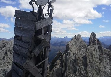
Remonter la crête à droite au Nord-Ouest jusqu'au gros cairn sommital (endroit idéal pour un pique nique et la contemplation).

Effectuer le retour en sens inverse par le même itinéraire jusqu'au parking (D/A).

Elevation profile

Points of interest

Point of interest Le Monêtier-les-Bains - Parking - Photo
Thomasdanielle
LE MONÊTIER-LES-BAINS 
Point of interest Villar-d'Arêne - Gros cairn - Photo
Thomasdanielle
VILLAR-D'ARÊNE 
Point of interest Le Monêtier-les-Bains - Col de Côte Plaine - Photo
Thomasdanielle
LE MONÊTIER-LES-BAINS 
Point of interest Le Monêtier-les-Bains - Changement de cap - Photo
Thomasdanielle
LE MONÊTIER-LES-BAINS 
Point of interest Le Monêtier-les-Bains - Bout du sentier - Photo
Thomasdanielle
LE MONÊTIER-LES-BAINS 
Point of interest Le Monêtier-les-Bains - Parking - Photo
Thomasdanielle
LE MONÊTIER-LES-BAINS 

Positioning

Country:
France
Region :
Provence-Alpes-Côte d'Azur
Department/Province :
Hautes-Alpes
Municipality :
Le Monêtier-les-Bains
Location:
Unknown
Start:(UTM)
294456 ; 4992018 (32T) N.

Trails nearby

Trail Walking Valloire - Le Pic de l'Aigle (ou presque), 2776m - Photo
Walking
tracegps

Walking

Medium
(1)
Valloire, Auvergne-Rhône-Alpes, Savoy, France
11.2 km | 22 km-effort
5h 45min
Yes
Trail Walking La Grave - L'aiguille du Goléon - Photo
Walking
tracegps

Walking

Very difficult
(1)
La Grave, Provence-Alpes-Côte d'Azur, Hautes-Alpes, France
9.1 km | 25 km-effort
5h 0min
No
Trail Walking Villar-d'Arêne - Lac d'Arsine  - Photo
Walking
GUIDE
nadinebondoux

Walking

Difficult
Villar-d'Arêne, Provence-Alpes-Côte d'Azur, Hautes-Alpes, France
17.2 km | 28 km-effort
5h 37min
Yes
Trail Walking Le Monêtier-les-Bains - Pic Blanc du Galibier - Photo
Walking
GUIDE
amiral13

Walking

Medium
Le Monêtier-les-Bains, Provence-Alpes-Côte d'Azur, Hautes-Alpes, France
4.3 km | 9.9 km-effort
2h 51min
Yes
Trail Walking Valloire - le grand Galibier par le plan lachat - Photo
Walking
GUIDE
amiral13

Walking

Difficult
Valloire, Auvergne-Rhône-Alpes, Savoy, France
19.1 km | 36 km-effort
5h 50min
Yes
Trail Walking Villar-d'Arêne - SityTrail - Lac du pontet et l'Aiguillon - Photo
Walking

Walking

Medium
(1)
Villar-d'Arêne, Provence-Alpes-Côte d'Azur, Hautes-Alpes, France
5.7 km | 9.6 km-effort
2h 10min
Yes
Trail Walking Villar-d'Arêne - le refuge de l'alpe de Villard d’arène  - Photo
Walking
GUIDE
amiral13

Walking

Easy
(1)
Villar-d'Arêne, Provence-Alpes-Côte d'Azur, Hautes-Alpes, France
10 km | 15.3 km-effort
3h 28min
Yes
Trail Walking Valloire - Pointe des Cerces - Photo
Walking
GUIDE
amiral13

Walking

Difficult
Valloire, Auvergne-Rhône-Alpes, Savoy, France
15.1 km | 30 km-effort
6h 37min
Yes
Trail Walking Valloire - Plan Lachat Les 3 lacs - Photo
Walking
psesjs

Walking

Medium
(2)
Valloire, Auvergne-Rhône-Alpes, Savoy, France
10.6 km | 19.2 km-effort
Unknown
Yes


Close
My subscriptions