


Saint-Sulpice-sur -Lèze pesquiès

pidjam
User
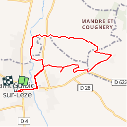

Length
9.5 km

Max alt
278 m

Uphill gradient
179 m
Km-Effort
11.9 km

Min alt
193 m

Downhill gradient
178 m
Boucle
Yes
Creation date :
2019-06-14 09:37:34.695
Updated on :
2019-06-14 09:45:16.473
2h32
Difficulty : Medium

FREE GPS app for hiking
 SityTrail
IGN / Geographical institutes
SityTrail Plus
The world is yours!
About
Trail Walking of 9.5 km to be discovered at Occitania, Haute-Garonne, Saint-Sulpice-sur-Lèze. This trail is proposed by pidjam.
Description
rando de "sud ouest toulousain randonnées"
reste à valider l'existence du chemin le long de la Lèze...
Positioning
Country:
France
Region :
Occitania
Department/Province :
Haute-Garonne
Municipality :
Saint-Sulpice-sur-Lèze
Location:
Unknown
Start:(Dec)
Start:(UTM)
363819 ; 4798598 (31T) N.
Comments