Trail Bicycle tourism Poncin - Poncin - Frontenas - Photo

Poncin - Frontenas

© OpenStreetMap contributors
Length
Length
69 km
Max alt
Max alt
304 m
Uphill gradient
Uphill gradient
463 m
Km-Effort
Km-Effort  
75 km
Min alt
Min alt
191 m
Downhill gradient
Downhill gradient
519 m
Boucle
Boucle
No
Creation date :
2019-06-14 06:48:49.279
Updated on :
2019-06-14 14:30:07.703

(0 Reviews)

Bicycle tourism
Bicycle tourism
3h56
Difficulty : Very easy

Scan this QR Code to open this trail in the SityTrail application

FREE GPS app for hiking

Logo SityTrail SityTrail

IGN / Geographical institutes

Download SityTrail from the App Store Download SityTrail from Google Play

Logo SityTrail SityTrail World

The world is yours!

Download SityTrail from the App Store Download SityTrail from Google Play Download SityTrail on Huawei AppGallery

About

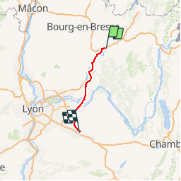
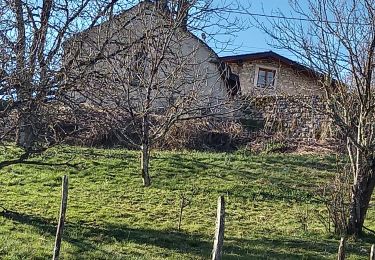
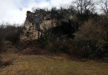
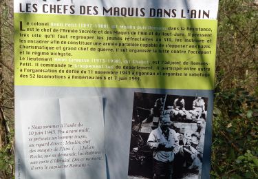
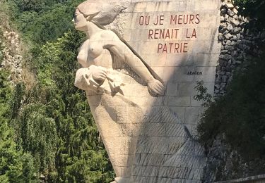
Trail Bicycle tourism of 69 km to be discovered at Auvergne-Rhône-Alpes, Ain, Poncin. This trail is proposed by karawatsj.

Description

Langs de benedenloop van de Ain naar de Rhône richting de Provence.
Vlakke tocht.

Elevation profile

Photos

Positioning

Country:
France
Region :
Auvergne-Rhône-Alpes
Department/Province :
Ain
Municipality :
Poncin
Location:
Unknown
Start:(UTM)
686129 ; 5106436 (31T) N.

Trails nearby

Trail Walking Challes-la-Montagne - challes la montagne barrage lallement la cueille sameriat - Photo
Walking
loca.yves

Walking

Easy
Challes-la-Montagne, Auvergne-Rhône-Alpes, Ain, France
10 km | 14.3 km-effort
3h 10min
Yes
Trail Walking Cerdon - 01_CERDON_CASCADE_FOUGE_18 km_780m - Photo
Walking
SyMA

Walking

Difficult
Cerdon, Auvergne-Rhône-Alpes, Ain, France
17.8 km | 28 km-effort
6h 22min
Yes
Trail Walking Poncin - les bords de l ain depart povin - Photo
Walking
colomb24

Walking

Very difficult
Poncin, Auvergne-Rhône-Alpes, Ain, France
23 km | 32 km-effort
6h 25min
Yes
Trail Walking Jujurieux - 01-Jujurieux-Neuville-restau-18-7km-440m-fev22 - Photo
Walking
SyMA

Walking

Medium
Jujurieux, Auvergne-Rhône-Alpes, Ain, France
18.6 km | 25 km-effort
4h 54min
Yes
Trail Walking Cerdon - Le cerdon parr le drapeau  - Photo
Walking
colomb24

Walking

Difficult
Cerdon, Auvergne-Rhône-Alpes, Ain, France
19.1 km | 31 km-effort
6h 41min
Yes
Trail Road bike Poncin - Circuit l'Ain à vélo n° 22 - Et au milieu coule une rivière... - Photo
Road bike
jpfrobert

Road bike

Very difficult
Poncin, Auvergne-Rhône-Alpes, Ain, France
59 km | 72 km-effort
4h 9min
No
Trail Walking Cerdon - Cerdon  : La cascade de Fouges (18 km - D. 823 m)  - Photo
Walking
Thomasdanielle

Walking

Very difficult
Cerdon, Auvergne-Rhône-Alpes, Ain, France
17.9 km | 29 km-effort
6h 36min
Yes
Trail Walking Jujurieux - les châteaux de jujurieux  - Photo
Walking
colomb24

Walking

Easy
Jujurieux, Auvergne-Rhône-Alpes, Ain, France
14 km | 18.4 km-effort
4h 29min
Yes
Trail Walking Pont-d'Ain - pont d'ain château d'hterive - Photo
Walking
loca.yves

Walking

Difficult
Pont-d'Ain, Auvergne-Rhône-Alpes, Ain, France
15.1 km | 16.1 km-effort
3h 54min
Yes


Close
My subscriptions