Trail Walking Eyzin-Pinet - Eyzin Pinet - les Blaches - 10,8 km - 154 m de dénivelé - 3h30 - Photo

Eyzin Pinet - les Blaches - 10,8 km - 154 m de dénivelé - 3h30

© OpenStreetMap contributors
Length
Length
10.8 km
Max alt
Max alt
460 m
Uphill gradient
Uphill gradient
154 m
Km-Effort
Km-Effort  
12.8 km
Min alt
Min alt
384 m
Downhill gradient
Downhill gradient
150 m
Boucle
Boucle
Yes
Creation date :
2019-06-25 14:11:19.453
Updated on :
2023-02-26 10:55:35.772

(0 Reviews)

Walking
Walking
3h30
Difficulty : Medium

Scan this QR Code to open this trail in the SityTrail application

FREE GPS app for hiking

Logo SityTrail SityTrail

IGN / Geographical institutes

Download SityTrail from the App Store Download SityTrail from Google Play

Logo SityTrail SityTrail World

The world is yours!

Download SityTrail from the App Store Download SityTrail from Google Play Download SityTrail on Huawei AppGallery

About

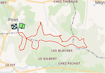
Trail Walking of 10.8 km to be discovered at Auvergne-Rhône-Alpes, Isère, Eyzin-Pinet. This trail is proposed by Clubléorando.

Description

Balade en boucle au départ du sentier de la forêt domanial des Blaches. Boucle intégralement dans les bois

Elevation profile

Positioning

Country:
France
Region :
Auvergne-Rhône-Alpes
Department/Province :
Isère
Municipality :
Eyzin-Pinet
Location:
Unknown
Start:(UTM)
656705 ; 5035730 (31T) N.

Trails nearby

Trail Mountain bike Monsteroux-Milieu - sanglier - Photo
Mountain bike
phusser

Mountain bike

Very easy
(1)
Monsteroux-Milieu, Auvergne-Rhône-Alpes, Isère, France
40 km | 51 km-effort
4h 49min
Yes
Trail Walking Cour-et-Buis - 38-Cour-et-Buis-Eyzin-restau-18km-420mdec22 - Photo
Walking
SyMA

Walking

Medium
(1)
Cour-et-Buis, Auvergne-Rhône-Alpes, Isère, France
20 km | 26 km-effort
5h 41min
Yes
Trail Walking Monsteroux-Milieu - Le Sanglier 2013 - Montsevenoux - Photo
Walking
tracegps

Walking

Medium
Monsteroux-Milieu, Auvergne-Rhône-Alpes, Isère, France
15.5 km | 20 km-effort
3h 30min
Yes
Trail On foot Meyssiez - Meyssiez - 10,7 km - 297 m de dénivelé - 3h30 - Photo
On foot
Clubléorando

On foot

Medium
Meyssiez, Auvergne-Rhône-Alpes, Isère, France
10.7 km | 14.7 km-effort
3h 30min
Yes
Trail On foot Eyzin-Pinet - Eyzin Pinet - château Pinet - 11 km - 298 m de dénivelé - 4h - Photo
On foot
Clubléorando

On foot

Medium
Eyzin-Pinet, Auvergne-Rhône-Alpes, Isère, France
11 km | 15 km-effort
4h 0min
Yes
Trail On foot Montseveroux - Montseveroux - la chèvrerie de la combe Bernard - 12,1 km - 222 m de dénivelé - 3h30 - Photo
On foot
Clubléorando

On foot

Medium
Montseveroux, Auvergne-Rhône-Alpes, Isère, France
12.1 km | 15 km-effort
3h 30min
Yes
Trail On foot Eyzin-Pinet - Eyzin Pinet - les Blaches - 8,6 km - 131 m de dénivelé - 3h - Photo
On foot
Clubléorando

On foot

Easy
Eyzin-Pinet, Auvergne-Rhône-Alpes, Isère, France
8.6 km | 10.3 km-effort
3h 0min
Yes
Trail On foot Monsteroux-Milieu - Monsteroux Milieu - 11 km - 252 m de dénivelé  - 3h - Photo
On foot
Clubléorando

On foot

Medium
Monsteroux-Milieu, Auvergne-Rhône-Alpes, Isère, France
10.5 km | 13.9 km-effort
3h 0min
Yes
Trail On foot Eyzin-Pinet - Eyzin Pinet - château Pinet - 10,1 km - 184 m de dénivelé - 3h30 - Photo
On foot
Clubléorando

On foot

Easy
Eyzin-Pinet, Auvergne-Rhône-Alpes, Isère, France
10.1 km | 12.5 km-effort
3h 30min
Yes


Close
My subscriptions