Trail Walking Caubeyres - R2c2 - Photo
 Domie38
Domie38

User

© OpenStreetMap contributors
Length
Length
2.8 km
Max alt
Max alt
133 m
Uphill gradient
Uphill gradient
31 m
Km-Effort
Km-Effort  
3.2 km
Min alt
Min alt
110 m
Downhill gradient
Downhill gradient
31 m
Boucle
Boucle
Yes
Creation date :
2019-07-14 09:16:48.0
Updated on :
2019-07-14 10:11:58.718

(0 Reviews)

Walking
Walking
47m
Difficulty : Medium

Scan this QR Code to open this trail in the SityTrail application

FREE GPS app for hiking

Logo SityTrail SityTrail

IGN / Geographical institutes

Download SityTrail from the App Store Download SityTrail from Google Play

Logo SityTrail SityTrail World

The world is yours!

Download SityTrail from the App Store Download SityTrail from Google Play Download SityTrail on Huawei AppGallery

About

Trail Walking of 2.8 km to be discovered at New Aquitaine, Lot-et-Garonne, Caubeyres. This trail is proposed by Domie38.

Description

Petit tour à faire le latin avec un bâton pour enlever les toiles d’araignées et à pied à cause des chemins parfois de sable.

Elevation profile

Positioning

Country:
France
Region :
New Aquitaine
Department/Province :
Lot-et-Garonne
Municipality :
Caubeyres
Location:
Unknown
Start:(UTM)
276530 ; 4903912 (31T) N.

Trails nearby

Trail On foot Xaintrailles - Xaintrailles, la balade du château - 4.7 km - Photo
On foot
PRO

On foot

Easy
Xaintrailles, New Aquitaine, Lot-et-Garonne, France
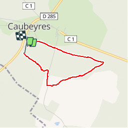
4.6 km | 5.9 km-effort
1h 19min
Yes
Trail On foot Fargues-sur-Ourbise - Fargues-sur-Ourbise, une île en forêt - 11.7 km - Photo
On foot
PRO

On foot

Easy
Fargues-sur-Ourbise, New Aquitaine, Lot-et-Garonne, France
9.9 km | 11.2 km-effort
2h 32min
No
Trail On foot Caubeyres - Caubeyres, la fontaine bouillonnante - 10.7 km - Photo
On foot
PRO

On foot

Easy
Caubeyres, New Aquitaine, Lot-et-Garonne, France
10.2 km | 12.8 km-effort
2h 54min
Yes
Trail On foot Damazan - Saint-Pierre-de-Buzet, la randonnée du Cap-du-Bosc - 12 km - Photo
On foot
PRO

On foot

Easy
Damazan, New Aquitaine, Lot-et-Garonne, France
14.1 km | 19 km-effort
4h 19min
Yes
Trail On foot Xaintrailles - Ambrus, la balade forestière de Pelane - 7.3 km - Photo
On foot
PRO

On foot

Easy
Xaintrailles, New Aquitaine, Lot-et-Garonne, France
7.1 km | 8.8 km-effort
1h 59min
Yes
Trail On foot Xaintrailles - Ambrus, promenade vers le vignoble de Padère - 9.5 km - Photo
On foot
PRO

On foot

Easy
Xaintrailles, New Aquitaine, Lot-et-Garonne, France
5.1 km | 6.1 km-effort
1h 23min
No
Trail On foot Xaintrailles - Ambrus, découverte de la forêt - 6.2 km - Photo
On foot
PRO

On foot

Easy
Xaintrailles, New Aquitaine, Lot-et-Garonne, France
6.2 km | 7.7 km-effort
1h 45min
Yes
Trail On foot Anzex - Anzex, la promenade de Pèleperdrix (7,9 km, balisage jaune) - Photo
On foot
PRO

On foot

Easy
Anzex, New Aquitaine, Lot-et-Garonne, France
7.6 km | 9.4 km-effort
2h 8min
No
Trail Walking Caubeyres - Antenne Caubeyres  - Photo
Walking
Domie38

Walking

Medium
Caubeyres, New Aquitaine, Lot-et-Garonne, France
9.4 km | 11.6 km-effort
2h 24min
Yes


Close
My subscriptions