


morakski kras

romain-donner
User
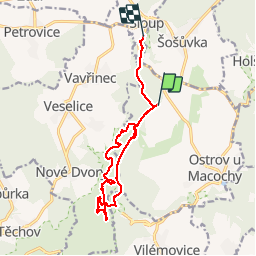

Length
12.8 km

Max alt
515 m

Uphill gradient
309 m
Km-Effort
17.1 km

Min alt
392 m

Downhill gradient
356 m
Boucle
No
Creation date :
2019-07-15 10:39:04.022
Updated on :
2019-07-15 15:04:04.165
3h33
Difficulty : Medium

FREE GPS app for hiking
 SityTrail
IGN / Geographical institutes
SityTrail World
The world is yours!
About
Trail Walking of 12.8 km to be discovered at Southeast, Jihomoravský kraj, Ostrov u Macochy. This trail is proposed by romain-donner.
Photos


Positioning
Country:
Czech Republic
Region :
Southeast
Department/Province :
Jihomoravský kraj
Municipality :
Ostrov u Macochy
Location:
Unknown
Start:(Dec)
Start:(UTM)
626499 ; 5472971 (33U) N.
Comments
Trails nearby