Trail Walking Barr - Autour de la vallée de la Kirneck - Photo

Autour de la vallée de la Kirneck

© OpenStreetMap contributors
Length
Length
9.8 km
Max alt
Max alt
791 m
Uphill gradient
Uphill gradient
419 m
Km-Effort
Km-Effort  
15.4 km
Min alt
Min alt
368 m
Downhill gradient
Downhill gradient
420 m
Boucle
Boucle
Yes
Creation date :
2019-07-15 08:44:22.655
Updated on :
2019-07-18 19:20:17.736

(0 Reviews)

Walking
Walking
3h04
Difficulty : Medium

Scan this QR Code to open this trail in the SityTrail application

FREE GPS app for hiking

Logo SityTrail SityTrail

IGN / Geographical institutes

Download SityTrail from the App Store Download SityTrail from Google Play

Logo SityTrail SityTrail World

The world is yours!

Download SityTrail from the App Store Download SityTrail from Google Play Download SityTrail on Huawei AppGallery

About

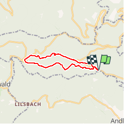
Trail Walking of 9.8 km to be discovered at Grand Est, Bas-Rhin, Barr. This trail is proposed by VacheKiri67.

Description

Faite le 15/07/2019. D'après "Passion Vosges - Autour du Mont Sainte-Odile" N°21 : Autour de la vallée de la Kirneck. Durée indiquée pour le circuit : 3h15. Parcours sans curiosité particulière, c'est plutôt un circuit de remise en jambe.

Elevation profile

Photos

Positioning

Country:
France
Region :
Grand Est
Department/Province :
Bas-Rhin
Municipality :
Barr
Location:
Unknown
Start:(UTM)
381760 ; 5363134 (32U) N.

Trails nearby

Trail Walking Ottrott - Le circuit sud du Mur Païen - Photo
Walking
VacheKiri67

Walking

Easy
(2)
Ottrott, Grand Est, Bas-Rhin, France
4.9 km | 6.3 km-effort
1h 56min
No
Trail Walking Ottrott - Le circuit nord du Mur Païen - Photo
Walking
VacheKiri67

Walking

Easy
(1)
Ottrott, Grand Est, Bas-Rhin, France
5.9 km | 8.5 km-effort
2h 4min
No
Trail Walking Andlau - Depuis Andlau vers le village viticole de Mittelbergheim - Photo
Walking
VacheKiri67

Walking

Medium
(1)
Andlau, Grand Est, Bas-Rhin, France
11.9 km | 15.9 km-effort
4h 3min
Yes
Trail Walking Ottrott - Le mur païen - Photo
Walking
VacheKiri67

Walking

Medium
(4)
Ottrott, Grand Est, Bas-Rhin, France
10.5 km | 14.5 km-effort
4h 36min
Yes
Trail Walking Ottrott - Mur Paien complet - Photo
Walking
markrei

Walking

Medium
(1)
Ottrott, Grand Est, Bas-Rhin, France
12 km | 16.4 km-effort
5h 25min
Yes
Trail Mountain bike Barr - Circuit des 3 Petits Ponts - Photo
Mountain bike
tracegps

Mountain bike

Difficult
(1)
Barr, Grand Est, Bas-Rhin, France
15.9 km | 22 km-effort
1h 19min
Yes
Trail Walking Reichsfeld - 2019-12-28 Marche Reichsfeld Ungersberg Gruckert - Photo
Walking
GUIDE
holtzv

Walking

Very easy
Reichsfeld, Grand Est, Bas-Rhin, France
12.2 km | 20 km-effort
3h 5min
Yes
Trail Walking Obernai - sentier des merveilles - Photo
Walking
semila

Walking

Difficult
(1)
Obernai, Grand Est, Bas-Rhin, France
11 km | 16.6 km-effort
4h 8min
Yes
Trail Walking Ottrott - 2013-12-29 Marche Mt Ste Odile Maennelstein Birkenfels - Photo
Walking
GUIDE
holtzv

Walking

Medium
(1)
Ottrott, Grand Est, Bas-Rhin, France
10.8 km | 15.4 km-effort
3h 24min
Yes


Close
My subscriptions