Trail Mountain bike Landrecies - Landrecies - Sentier des étoquies - Photo

Landrecies - Sentier des étoquies

 Robert62
Robert62

User

© OpenStreetMap contributors
Length
Length
9.6 km
Max alt
Max alt
169 m
Uphill gradient
Uphill gradient
82 m
Km-Effort
Km-Effort  
10.7 km
Min alt
Min alt
130 m
Downhill gradient
Downhill gradient
82 m
Boucle
Boucle
Yes
Creation date :
2019-07-18 13:19:14.517
Updated on :
2019-07-18 14:14:48.724

(0 Reviews)

Mountain bike
Mountain bike
43m
Difficulty : Easy

Scan this QR Code to open this trail in the SityTrail application

FREE GPS app for hiking

Logo SityTrail SityTrail

IGN / Geographical institutes

Download SityTrail from the App Store Download SityTrail from Google Play

Logo SityTrail SityTrail World

The world is yours!

Download SityTrail from the App Store Download SityTrail from Google Play Download SityTrail on Huawei AppGallery

About

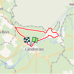
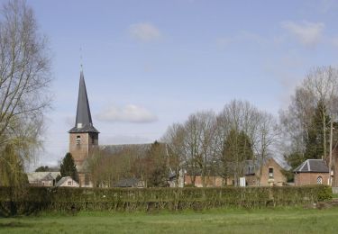
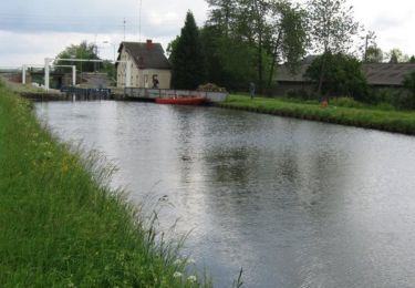
Trail Mountain bike of 9.6 km to be discovered at Hauts-de-France, Nord, Landrecies. This trail is proposed by Robert62.

Description

Parcours à faire en VTT par temps sec au départ du pont du canal à Landrecies (mise à jour à faire après la rando dans les prochains jours).
Le sentier emprunte principalement le GR 122 dans la partie Nord, après avoir franchi la voie ferrée, on revient vers la Sambre par le sentier des Mauviards en longeant le canal de la Sambre à l'Oise et arriver à Landrecies près de l'ancienne caserne

Elevation profile

Positioning

Country:
France
Region :
Hauts-de-France
Department/Province :
Nord
Municipality :
Landrecies
Location:
Unknown
Start:(UTM)
549141 ; 5553005 (31U) N.

Trails nearby

Trail Walking Landrecies - Landrecies 18 km - Photo
Walking
GUIDE
rvapeldo

Walking

Easy
Landrecies, Hauts-de-France, Nord, France
18 km | 20 km-effort
5h 32min
Yes
Trail Walking Locquignol - Hachette.  Berges de Sambre et forêt  - Photo
Walking
ayumi atsu

Walking

Medium
Locquignol, Hauts-de-France, Nord, France
9.7 km | 10.9 km-effort
1h 42min
Yes
Trail Walking Preux-au-Bois - Circuit de Preux au Bois - Photo
Walking
terminio

Walking

Easy
(1)
Preux-au-Bois, Hauts-de-France, Nord, France
11.3 km | 12.8 km-effort
2h 49min
Yes
Trail Walking Ors - Sentier de bois l'Evèque - Photo
Walking

Walking

Very easy
Ors, Hauts-de-France, Nord, France
6.5 km | 7.3 km-effort
Unknown
Yes
Trail Walking Landrecies - Sentier des Etoquies - Landrecies - Photo
Walking
tracegps

Walking

Medium
(1)
Landrecies, Hauts-de-France, Nord, France
9.6 km | 10.6 km-effort
2h 25min
Yes
Trail Walking Preux-au-Bois - Circuit de Preux - au - Bois - Photo
Walking
tracegps

Walking

Easy
(1)
Preux-au-Bois, Hauts-de-France, Nord, France
10.3 km | 11.8 km-effort
2h 40min
Yes
Trail Walking Ors - Sentier de Bois l'évêque  (Ors)   - Photo
Walking
tracegps

Walking

Medium
Ors, Hauts-de-France, Nord, France
11.2 km | 12.7 km-effort
2h 49min
Yes
Trail Mountain bike Fontaine-au-Bois - VTT de Fontaine au Bois - Photo
Mountain bike
tracegps

Mountain bike

Easy
(1)
Fontaine-au-Bois, Hauts-de-France, Nord, France
13.5 km | 14.8 km-effort
1h 30min
Yes
Trail Mountain bike Landrecies - F.LandreciesMontdidier37C119.517VTT0 - Photo
Mountain bike
francois58

Mountain bike

Easy
Landrecies, Hauts-de-France, Nord, France
119 km | 131 km-effort
8h 36min
No


Close
My subscriptions