Trail Walking Laroque-des-Albères - RP66 LAROQUE-DES-ALBÈRES tour  - Photo
 jeff66
jeff66

User

© OpenStreetMap contributors
Length
Length
8.9 km
Max alt
Max alt
190 m
Uphill gradient
Uphill gradient
132 m
Km-Effort
Km-Effort  
10.7 km
Min alt
Min alt
80 m
Downhill gradient
Downhill gradient
132 m
Boucle
Boucle
Yes
Creation date :
2019-07-19 05:45:36.0
Updated on :
2019-07-19 07:39:00.806

(0 Reviews)

Walking
Walking
1h31
Difficulty : Difficult

Scan this QR Code to open this trail in the SityTrail application

FREE GPS app for hiking

Logo SityTrail SityTrail

IGN / Geographical institutes

Download SityTrail from the App Store Download SityTrail from Google Play

Logo SityTrail SityTrail World

The world is yours!

Download SityTrail from the App Store Download SityTrail from Google Play Download SityTrail on Huawei AppGallery

About

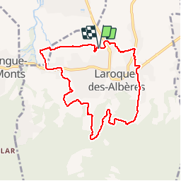
Trail Walking of 8.9 km to be discovered at Occitania, Pyrénées-Orientales, Laroque-des-Albères. This trail is proposed by jeff66.

Description

RP66 LAROQUE-DES-ALBÈRES - les vernèdes - mas rancoure - les olivedes - mas del gasco - chapelle de la Roca Vella - gué - canal - mas d’en bordes - mas malzac - mas blanc - mas manères - av. de la côte vermeille - cimetiere - Tanya - le 19.07.2019

Elevation profile

Positioning

Country:
France
Region :
Occitania
Department/Province :
Pyrénées-Orientales
Municipality :
Laroque-des-Albères
Location:
Unknown
Start:(UTM)
494300 ; 4708456 (31T) N.

Trails nearby

Trail Walking Laroque-des-Albères - 66 LAROQUE DES ALBERES (maison) SOREDE, par pistes DFCI AL12 et 19, mas del Ca et mas Manere, Itin.16  - Photo
Walking
jeff66

Walking

Medium
(1)
Laroque-des-Albères, Occitania, Pyrénées-Orientales, France
11.2 km | 15.3 km-effort
2h 5min
Yes
Trail Walking Laroque-des-Albères - 66 SOREDE, LAROQUE DES ALBERES, chemins des Mas - Photo
Walking
jeff66

Walking

Medium
(1)
Laroque-des-Albères, Occitania, Pyrénées-Orientales, France
7 km | 8.9 km-effort
1h 22min
Yes
Trail Walking Saint-André - 66 SAINT-ANDRE - SOREDE - chapelle Saint Ferreol de la Pava  - Photo
Walking
jeff66

Walking

Medium
(1)
Saint-André, Occitania, Pyrénées-Orientales, France
14.2 km | 16.9 km-effort
2h 25min
Yes
Trail Walking L'Albère - SAINT-JEAN-D'ALBERE 66 - PUIG  de Sant Christau par le coll de Sant Joan  - Photo
Walking
jeff66

Walking

Difficult
(1)
L'Albère, Occitania, Pyrénées-Orientales, France
10.1 km | 17 km-effort
2h 46min
Yes
Trail Walking Montesquieu-des-Albères - MONTESQUIEU-DES-ALBERES 66 - Les Agouillous - les chemins de l'eau dans les Albères - Photo
Walking
jeff66

Walking

Medium
(1)
Montesquieu-des-Albères, Occitania, Pyrénées-Orientales, France
12.7 km | 13.9 km-effort
2h 16min
Yes
Trail Walking Palau-del-Vidre - PALAU-DEL-VIDRE 66 - Boucle de Villeclare - promenade dans les vergers et cultures maraîchères  - Photo
Walking
jeff66

Walking

Easy
(2)
Palau-del-Vidre, Occitania, Pyrénées-Orientales, France
7.5 km | 7.9 km-effort
1h 16min
Yes
Trail Walking Sorède - Utrera Font Miracles T - Photo
Walking
force

Walking

Medium
(1)
Sorède, Occitania, Pyrénées-Orientales, France
10.7 km | 17.6 km-effort
3h 50min
Yes
Trail Walking Sorède - 577. 11km sorede roc des medes  - Photo
Walking
Erius

Walking

Medium
(1)
Sorède, Occitania, Pyrénées-Orientales, France
10.5 km | 18.2 km-effort
3h 42min
Yes
Trail Walking Laroque-des-Albères - Col-Ullat Pic-aureille_Terrain - Photo
Walking
force

Walking

Medium
(1)
Laroque-des-Albères, Occitania, Pyrénées-Orientales, France
11.2 km | 23 km-effort
4h 47min
Yes


Close
My subscriptions