Trail Walking Wingen-sur-Moder - De Wingen sur Moder à Ingwiller - Photo

De Wingen sur Moder à Ingwiller

 tracegps
tracegps

User

© OpenStreetMap contributors
Length
Length
22 km
Max alt
Max alt
347 m
Uphill gradient
Uphill gradient
602 m
Km-Effort
Km-Effort  
30 km
Min alt
Min alt
183 m
Downhill gradient
Downhill gradient
635 m
Boucle
Boucle
No
Creation date :
2014-12-10 00:00:00.0
Updated on :
2014-12-10 00:00:00.0

(0 Reviews)

Walking
Walking
6h30
Difficulty : Difficult

Scan this QR Code to open this trail in the SityTrail application

FREE GPS app for hiking

Logo SityTrail SityTrail

IGN / Geographical institutes

Download SityTrail from the App Store Download SityTrail from Google Play

Logo SityTrail SityTrail World

The world is yours!

Download SityTrail from the App Store Download SityTrail from Google Play Download SityTrail on Huawei AppGallery

About

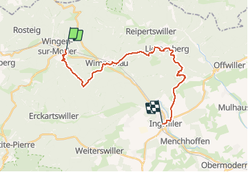
Trail Walking of 22 km to be discovered at Grand Est, Bas-Rhin, Wingen-sur-Moder. This trail is proposed by tracegps.

Description

Parcours qui chemine entre Wingen sur Moder et Ingwiller (67), au cœur d’une forêt mixte de l’Alsace du nord. Il faut si l’on veut prendre toute la mesure de ce circuit aller visiter le Musée Lalique à Wingen sur Moder, se plonger dans l’univers moyenâgeux du château de Lichtenberg ou/et s’attarder devant les panneaux pédagogiques du sentier botanique d’Ingwiller. Les points de départ et d'arrivée de cette randonnée sont desservis par le train.

Elevation profile

Photos

Points of interest

Point of interest Wingen-sur-Moder - Fin Lotissement - Photo
tracegps
WINGEN-SUR-MODER 
Point of interest Ingwiller - Gare Ingwiller - Photo
tracegps
INGWILLER 
Point of interest Wingen-sur-Moder - Gare Wingen - Photo
tracegps
WINGEN-SUR-MODER 
Point of interest Erckartswiller - Gr53Wimenau - Photo
tracegps
ERCKARTSWILLER 
Point of interest Lichtenberg - Panneau Stop - Photo
tracegps
LICHTENBERG 
Point of interest Wimmenau - Prendre à droite - Photo
tracegps

Positioning

Country:
France
Region :
Grand Est
Department/Province :
Bas-Rhin
Municipality :
Wingen-sur-Moder
Location:
Unknown
Start:(UTM)
381425 ; 5419823 (32U) N.

Trails nearby

Trail On foot Puberg - Disque vert - Photo
On foot
PRO

On foot

Medium
Puberg, Grand Est, Bas-Rhin, France
15.9 km | 20 km-effort
4h 39min
No
Trail On foot Zittersheim - Anneau jaune - Photo
On foot
PRO

On foot

Easy
Zittersheim, Grand Est, Bas-Rhin, France
9.5 km | 12.9 km-effort
2h 55min
Yes
Trail On foot Wimmenau - Rectangle jaune barré de blanc - Photo
On foot
PRO

On foot

Easy
Wimmenau, Grand Est, Bas-Rhin, France
4.7 km | 6.2 km-effort
1h 24min
No
Trail On foot Sparsbach - Chevalet rouge - Photo
On foot
PRO

On foot

Easy
Sparsbach, Grand Est, Bas-Rhin, France
3.2 km | 5.1 km-effort
1h 9min
No
Trail On foot Wingen-sur-Moder - Following in the footsteps of the Glass and Clog makers - Tour 1 - Photo
On foot
PRO

On foot

Medium
Wingen-sur-Moder, Grand Est, Bas-Rhin, France
17.4 km | 24 km-effort
5h 30min
Yes
Trail On foot Meisenthal - Mooncatchers permanent trail - 20 km - Photo
On foot
PRO

On foot

Easy
Meisenthal, Grand Est, Moselle, France
8.8 km | 11.7 km-effort
2h 39min
No
Trail On foot Soucht - Mooncatchers permanent trail - 10 km - Photo
On foot
PRO

On foot

Easy
Soucht, Grand Est, Moselle, France
9.3 km | 12.5 km-effort
2h 50min
Yes
Trail On foot Erckartswiller - Croix jaune - Photo
On foot
PRO

On foot

Easy
Erckartswiller, Grand Est, Bas-Rhin, France
5.1 km | 6.7 km-effort
1h 31min
No
Trail On foot Zittersheim - Sentier des 12 Sources - Photo
On foot
PRO

On foot

Easy
Zittersheim, Grand Est, Bas-Rhin, France
6.4 km | 9.6 km-effort
2h 10min
No


Close
My subscriptions