


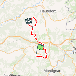

19.1 km | 23 km-effort

User


FREE GPS app for hiking
 SityTrail
IGN / Geographical institutes
SityTrail World
The world is yours!
Trail Mountain bike of 35 km to be discovered at New Aquitaine, Dordogne, Thenon. This trail is proposed by tracegps.
Au départ du Camping le Verdoyant à Thenon (avec retour au camping), ce circuit représente la 1ère étape avec pique-nique à Sainte Orse. La Boucle du Boscornut peut être supprimée mais ce serait dommage car c'est certainement une des plus belles de la zone.


Mountain bike

Mountain bike

Mountain bike

Walking

Walking
Mountain bike

Mountain bike

Walking