Trail On foot Sazos - Lacs d’Ardiden - Photo
 astro45
astro45

User

© OpenStreetMap contributors
Length
Length
6.4 km
Max alt
Max alt
2456 m
Uphill gradient
Uphill gradient
1026 m
Km-Effort
Km-Effort  
16.7 km
Min alt
Min alt
1427 m
Downhill gradient
Downhill gradient
1 m
Boucle
Boucle
No
Creation date :
2019-08-02 09:18:56.0
Updated on :
2019-09-21 16:24:52.725

(0 Reviews)

On foot
On foot
--
Difficulty : Difficult

Scan this QR Code to open this trail in the SityTrail application

FREE GPS app for hiking

Logo SityTrail SityTrail

IGN / Geographical institutes

Download SityTrail from the App Store Download SityTrail from Google Play

Logo SityTrail SityTrail World

The world is yours!

Download SityTrail from the App Store Download SityTrail from Google Play Download SityTrail on Huawei AppGallery

About

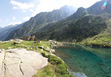
Trail On foot of 6.4 km to be discovered at Occitania, Hautespyrenees, Sazos. This trail is proposed by astro45.

Description

Découverte de plusieurs lacs d’altitude dans un val entouré de parois dominées par le pic d’Ardiden

Elevation profile

Positioning

Country:
France
Region :
Occitania
Department/Province :
Hautespyrenees
Municipality :
Sazos
Location:
Unknown
Start:(UTM)
741264 ; 4751525 (30T) N.

Trails nearby

Trail Walking Cauterets - Lac d'Estom - Photo
Walking
Philindy26

Walking

Medium
(1)
Cauterets, Occitania, Hautespyrenees, France
11.4 km | 17.5 km-effort
3h 30min
Yes
Trail Walking Sazos - Lac de Lagües - Photo
Walking
DuMarsan

Walking

Medium
(2)
Sazos, Occitania, Hautespyrenees, France
9.1 km | 18.9 km-effort
5h 14min
Yes
Trail Walking Grust - PIC DE VISCOS - Photo
Walking
PVERTICAL

Walking

Medium
(1)
Grust, Occitania, Hautespyrenees, France
10.5 km | 18.4 km-effort
4h 7min
Yes
Trail On foot Esterre - SityTrail - ESTERRE Viella / Luz /  Esquieze /  Esterre en boucle bis - Photo
On foot
GUIDE
marmotte65

On foot

Very easy
(1)
Esterre, Occitania, Hautespyrenees, France
9.4 km | 15.5 km-effort
Unknown
Yes
Trail Walking Cauterets - promenade Russell - Photo
Walking
pffrench

Walking

Very easy
(1)
Cauterets, Occitania, Hautespyrenees, France
11.9 km | 21 km-effort
5h 46min
Yes
Trail Walking Luz-Saint-Sauveur - Pic Bergons 2068m - Photo
Walking
tracegps

Walking

Medium
(1)
Luz-Saint-Sauveur, Occitania, Hautespyrenees, France
5.9 km | 14 km-effort
6h 0min
Yes
Trail Walking Sazos - Lac de Bastampe 2019m - Photo
Walking
tracegps

Walking

Difficult
(1)
Sazos, Occitania, Hautespyrenees, France
13 km | 27 km-effort
5h 0min
Yes
Trail On foot Esterre - ESTERRE  Villenave st Sauveur Luz Esterre G4
On foot
GUIDE
marmotte65

On foot

Easy
Esterre, Occitania, Hautespyrenees, France
9.4 km | 14.2 km-effort
3h 13min
Yes
Trail On foot Luz-Saint-Sauveur - LUZ SAINT SAUVEUR Les chemins de l agnouede bis - Photo
On foot
GUIDE
marmotte65

On foot

Easy
Luz-Saint-Sauveur, Occitania, Hautespyrenees, France
11.8 km | 18.5 km-effort
4h 12min
Yes


Close
My subscriptions