Trail Walking Ettal - Ettal - Linderhof 1908 - Photo
© OpenStreetMap contributors
Length
Length
12.8 km
Max alt
Max alt
1012 m
Uphill gradient
Uphill gradient
330 m
Km-Effort
Km-Effort  
17 km
Min alt
Min alt
846 m
Downhill gradient
Downhill gradient
266 m
Boucle
Boucle
No
Creation date :
2014-12-10 00:00:00.0
Updated on :
2014-12-10 00:00:00.0

(0 Reviews)

Walking
Walking
2h38
Difficulty : Unknown

Scan this QR Code to open this trail in the SityTrail application

FREE GPS app for hiking

Logo SityTrail SityTrail

IGN / Geographical institutes

Download SityTrail from the App Store Download SityTrail from Google Play

Logo SityTrail SityTrail World

The world is yours!

Download SityTrail from the App Store Download SityTrail from Google Play Download SityTrail on Huawei AppGallery

About

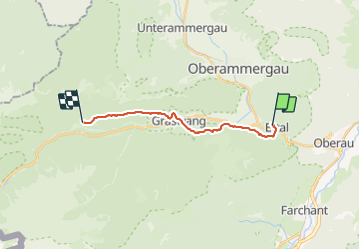
Trail Walking of 12.8 km to be discovered at Bavaria, Landkreis Garmisch-Partenkirchen, Ettal. This trail is proposed by thierry13710.

Elevation profile

Photos

Positioning

Country:
Germany
Region :
Bavaria
Department/Province :
Landkreis Garmisch-Partenkirchen
Municipality :
Ettal
Location:
Unknown
Start:(UTM)
657249 ; 5270651 (32T) N.

Trails nearby

Trail Walking Ettal - Ettal - Garmisch 200813 - Photo
Walking
thierry13710

Walking

Very easy
Ettal, Bavaria, Landkreis Garmisch-Partenkirchen, Germany
20 km | 31 km-effort
5h 26min
No
Trail On foot Oberammergau - BT 10 Ettaler Mandl - Photo
On foot
PRO

On foot

Easy
Oberammergau, Bavaria, Landkreis Garmisch-Partenkirchen, Germany
3 km | 5.3 km-effort
1h 12min
No
Trail Walking Oberammergau - Oberammergau - Ettal 1908 - Photo
Walking
thierry13710

Walking

Very easy
Oberammergau, Bavaria, Landkreis Garmisch-Partenkirchen, Germany
4.9 km | 7.1 km-effort
1h 14min
No


Close
My subscriptions