Trail Walking Nolay - Kévin randonnée  - Photo
 GUERLACH
GUERLACH

User

© OpenStreetMap contributors
Length
Length
10.6 km
Max alt
Max alt
519 m
Uphill gradient
Uphill gradient
353 m
Km-Effort
Km-Effort  
15.4 km
Min alt
Min alt
337 m
Downhill gradient
Downhill gradient
371 m
Boucle
Boucle
Yes
Creation date :
2019-08-11 06:36:46.246
Updated on :
2019-08-11 15:12:34.249

(0 Reviews)

Walking
Walking
3h24
Difficulty : Difficult

Scan this QR Code to open this trail in the SityTrail application

FREE GPS app for hiking

Logo SityTrail SityTrail

IGN / Geographical institutes

Download SityTrail from the App Store Download SityTrail from Google Play

Logo SityTrail SityTrail World

The world is yours!

Download SityTrail from the App Store Download SityTrail from Google Play Download SityTrail on Huawei AppGallery

About

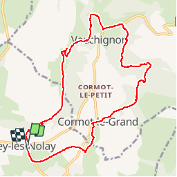
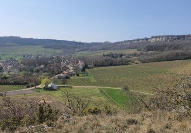
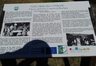
Trail Walking of 10.6 km to be discovered at Bourgogne-Franche-Comté, Côte-d'Or, Nolay. This trail is proposed by GUERLACH.

Description

Au retour vers Cirey-les-Nolay, la grimpette pour accéder au viaduc est très glissante. Faire très attention, sur tout s'il a plut.

Elevation profile

Positioning

Country:
France
Region :
Bourgogne-Franche-Comté
Department/Province :
Côte-d'Or
Municipality :
Nolay
Location:
Unknown
Start:(UTM)
623735 ; 5201820 (31T) N.

Trails nearby

Trail Walking Nolay - Circuit Jean-Marc Boivin - Nolay - Photo
Walking
tracegps

Walking

Very difficult
(2)
Nolay, Bourgogne-Franche-Comté, Côte-d'Or, France
47 km | 67 km-effort
10h 0min
Yes
Trail Walking La Rochepot - SityTrail - 2208667 - la-rochepot-fontaine-dxorches-page-34 - Photo
Walking
jcbossant

Walking

Very difficult
(1)
La Rochepot, Bourgogne-Franche-Comté, Côte-d'Or, France
17.9 km | 26 km-effort
5h 54min
Yes
Trail On foot Cormot-Vauchignon - Tour du Bout du Monde - Photo
On foot
PRO

On foot

Easy
Cormot-Vauchignon, Bourgogne-Franche-Comté, Côte-d'Or, France
10.1 km | 13.1 km-effort
2h 58min
Yes
Trail On foot La Rochepot - Sentier des Roches - Photo
On foot
PRO

On foot

Medium
La Rochepot, Bourgogne-Franche-Comté, Côte-d'Or, France
14.1 km | 21 km-effort
4h 46min
Yes
Trail Walking Baubigny - Sentier des roches - Photo
Walking
micheldutilleul

Walking

Difficult
(1)
Baubigny, Bourgogne-Franche-Comté, Côte-d'Or, France
15.2 km | 22 km-effort
4h 41min
Yes
Trail Walking Nolay - Nolay - Photo
Walking
pensionisten71

Walking

Very difficult
Nolay, Bourgogne-Franche-Comté, Côte-d'Or, France
18.6 km | 27 km-effort
4h 34min
Yes
Trail Walking Baubigny - 25-03-2022 Baubigny - Saint Romain  - Photo
Walking
GUIDE
Kargil

Walking

Medium
Baubigny, Bourgogne-Franche-Comté, Côte-d'Or, France
15.4 km | 22 km-effort
3h 35min
Yes
Trail Walking Cormot-Vauchignon - Vauchignon par de la le bout du monde page 9 - Photo
Walking
grasgilbert

Walking

Difficult
(4)
Cormot-Vauchignon, Bourgogne-Franche-Comté, Côte-d'Or, France
12.5 km | 16.8 km-effort
3h 14min
Yes
Trail Walking La Rochepot - La Rochepot Fontaine d'Orches page 34 - Photo
Walking
grasgilbert

Walking

Difficult
La Rochepot, Bourgogne-Franche-Comté, Côte-d'Or, France
17.9 km | 25 km-effort
5h 42min
Yes


Close
My subscriptions