Trail Walking Aussurucq - Forêt des Arbalètes, source de la Bidouze  - Photo

Forêt des Arbalètes, source de la Bidouze

 pacha56
pacha56

User

© OpenStreetMap contributors
Length
Length
13.9 km
Max alt
Max alt
1151 m
Uphill gradient
Uphill gradient
509 m
Km-Effort
Km-Effort  
21 km
Min alt
Min alt
709 m
Downhill gradient
Downhill gradient
630 m
Boucle
Boucle
No
Creation date :
2019-08-20 10:01:55.637
Updated on :
2019-08-20 17:51:22.668

(0 Reviews)

Walking
Walking
5h24
Difficulty : Medium

Scan this QR Code to open this trail in the SityTrail application

FREE GPS app for hiking

Logo SityTrail SityTrail

IGN / Geographical institutes

Download SityTrail from the App Store Download SityTrail from Google Play

Logo SityTrail SityTrail World

The world is yours!

Download SityTrail from the App Store Download SityTrail from Google Play Download SityTrail on Huawei AppGallery

About

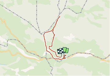
Trail Walking of 13.9 km to be discovered at New Aquitaine, Pyrénées-Atlantiques, Aussurucq. This trail is proposed by pacha56.

Description

belle ballade pastorale et en forêt,  sentier très gras par endroits.

Elevation profile

Positioning

Country:
France
Region :
New Aquitaine
Department/Province :
Pyrénées-Atlantiques
Municipality :
Aussurucq
Location:
Unknown
Start:(UTM)
661057 ; 4773356 (30T) N.

Trails nearby

Trail Walking Mendive - randogps64-486  - Photo
Walking
DECHAMPD

Walking

Very difficult
Mendive, New Aquitaine, Pyrénées-Atlantiques, France
13.6 km | 25 km-effort
4h 58min
Yes
Trail Walking Lacarry-Arhan-Charritte-de-Haut - D7 - GR 10 - Photo
Walking
loic09

Walking

Medium
Lacarry-Arhan-Charritte-de-Haut, New Aquitaine, Pyrénées-Atlantiques, France
16.7 km | 30 km-effort
6h 9min
No


Close
My subscriptions