Trail Walking Ottrott - klingenthal mont saint Odile - Photo

klingenthal mont saint Odile

© OpenStreetMap contributors
Length
Length
13.9 km
Max alt
Max alt
769 m
Uphill gradient
Uphill gradient
554 m
Km-Effort
Km-Effort  
21 km
Min alt
Min alt
324 m
Downhill gradient
Downhill gradient
551 m
Boucle
Boucle
Yes
Creation date :
2019-08-29 08:08:01.852
Updated on :
2019-08-30 07:51:12.529

(0 Reviews)

Walking
Walking
3h55
Difficulty : Medium

Scan this QR Code to open this trail in the SityTrail application

FREE GPS app for hiking

Logo SityTrail SityTrail

IGN / Geographical institutes

Download SityTrail from the App Store Download SityTrail from Google Play

Logo SityTrail SityTrail World

The world is yours!

Download SityTrail from the App Store Download SityTrail from Google Play Download SityTrail on Huawei AppGallery

About

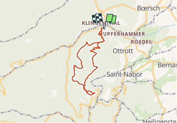
Trail Walking of 13.9 km to be discovered at Grand Est, Bas-Rhin, Ottrott. This trail is proposed by BernardThiry.

Description

très belle promenade qui monte au château d'Ottrott sentier des merveilles mur païen Mont Saint-Odile retour par boucle mur païen

Elevation profile

Photos

Positioning

Country:
France
Region :
Grand Est
Department/Province :
Bas-Rhin
Municipality :
Ottrott
Location:
Unknown
Start:(UTM)
382505 ; 5369381 (32U) N.

Trails nearby

Trail Walking Ottrott - Le circuit sud du Mur Païen - Photo
Walking
VacheKiri67

Walking

Easy
(2)
Ottrott, Grand Est, Bas-Rhin, France
4.9 km | 6.3 km-effort
1h 56min
No
Trail Walking Ottrott - Le circuit nord du Mur Païen - Photo
Walking
VacheKiri67

Walking

Easy
(1)
Ottrott, Grand Est, Bas-Rhin, France
5.9 km | 8.5 km-effort
2h 4min
No
Trail Walking Ottrott - Le Mont Sainte-Odile depuis Otrott - Photo
Walking
VacheKiri67

Walking

Medium
(1)
Ottrott, Grand Est, Bas-Rhin, France
13 km | 20 km-effort
6h 18min
Yes
Trail Walking Ottrott - Montée vers le Mont Sainte-Odile - Photo
Walking
VacheKiri67

Walking

Difficult
(1)
Ottrott, Grand Est, Bas-Rhin, France
17.6 km | 26 km-effort
5h 52min
Yes
Trail Walking Ottrott - Le mur païen - Photo
Walking
VacheKiri67

Walking

Medium
(4)
Ottrott, Grand Est, Bas-Rhin, France
10.5 km | 14.5 km-effort
4h 36min
Yes
Trail Walking Ottrott - Mur Paien complet - Photo
Walking
markrei

Walking

Medium
(1)
Ottrott, Grand Est, Bas-Rhin, France
12 km | 16.4 km-effort
5h 25min
Yes
Trail Mountain bike Barr - Circuit des 3 Petits Ponts - Photo
Mountain bike
tracegps

Mountain bike

Difficult
(1)
Barr, Grand Est, Bas-Rhin, France
15.9 km | 22 km-effort
1h 19min
Yes
Trail Mountain bike Ottrott - Sainte-Odile East-Face - Photo
Mountain bike
tracegps

Mountain bike

Difficult
(1)
Ottrott, Grand Est, Bas-Rhin, France
24 km | 39 km-effort
3h 0min
Yes
Trail Horseback riding Mollkirch - 2023-05-28 Picnic CVA Cabane des 5 routes - Photo
Horseback riding
GUIDE
holtzv

Horseback riding

Medium
Mollkirch, Grand Est, Bas-Rhin, France
36 km | 51 km-effort
6h 39min
Yes


Close
My subscriptions