Trail Walking Saint-Laurent-en-Beaumont - Malbuisson huat - Photo
 fhg5282
fhg5282

User

© OpenStreetMap contributors
Length
Length
6.4 km
Max alt
Max alt
884 m
Uphill gradient
Uphill gradient
318 m
Km-Effort
Km-Effort  
10.7 km
Min alt
Min alt
625 m
Downhill gradient
Downhill gradient
318 m
Boucle
Boucle
Yes
Creation date :
2019-08-30 08:11:16.403
Updated on :
2019-08-30 10:37:25.9

(0 Reviews)

Walking
Walking
2h03
Difficulty : Very easy

Scan this QR Code to open this trail in the SityTrail application

FREE GPS app for hiking

Logo SityTrail SityTrail

IGN / Geographical institutes

Download SityTrail from the App Store Download SityTrail from Google Play

Logo SityTrail SityTrail World

The world is yours!

Download SityTrail from the App Store Download SityTrail from Google Play Download SityTrail on Huawei AppGallery

About

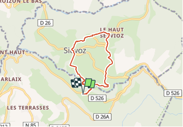
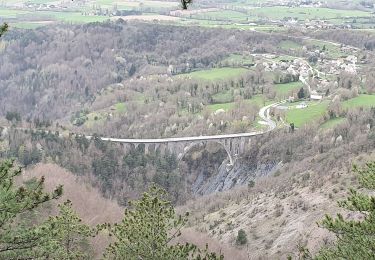
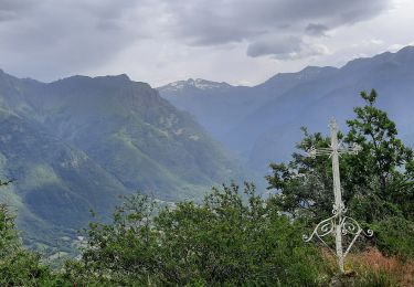
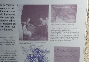
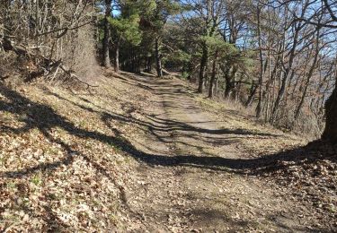
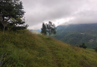
Trail Walking of 6.4 km to be discovered at Auvergne-Rhône-Alpes, Isère, Saint-Laurent-en-Beaumont. This trail is proposed by fhg5282.

Description

Malbuisson - Haut Sievoz

Elevation profile

Positioning

Country:
France
Region :
Auvergne-Rhône-Alpes
Department/Province :
Isère
Municipality :
Saint-Laurent-en-Beaumont
Location:
Unknown
Start:(UTM)
724494 ; 4974902 (31T) N.

Trails nearby

Trail Road bike La Mure - La Mure les 4 lacs - Photo
Road bike
Uio73

Road bike

Medium
(1)
La Mure, Auvergne-Rhône-Alpes, Isère, France
58 km | 72 km-effort
4h 22min
Yes
Trail Walking Sainte-Luce - Côte Rouge  - Photo
Walking
GuyVachet

Walking

Very difficult
Sainte-Luce, Auvergne-Rhône-Alpes, Isère, France
10.7 km | 21 km-effort
6h 59min
Yes
Trail Walking Nantes-en-Rattier - NANTES EN RATIER - Photo
Walking
floup6138

Walking

Easy
Nantes-en-Rattier, Auvergne-Rhône-Alpes, Isère, France
13.9 km | 21 km-effort
4h 23min
Yes
Trail Walking La Mure - Sur les Pas des Huguenots  -    La Mure -  Laffrey - Photo
Walking
tracegps

Walking

Very difficult
La Mure, Auvergne-Rhône-Alpes, Isère, France
15.9 km | 21 km-effort
4h 30min
No
Trail Walking Nantes-en-Rattier - tour de la forêt de la Roisonne - Photo
Walking
bailleulherve

Walking

Easy
Nantes-en-Rattier, Auvergne-Rhône-Alpes, Isère, France
7.3 km | 12.1 km-effort
2h 9min
No
Trail Walking Saint-Laurent-en-Beaumont - Croix de la Roche et Signal St-Michel - Photo
Walking
GuyVachet

Walking

Very difficult
Saint-Laurent-en-Beaumont, Auvergne-Rhône-Alpes, Isère, France
14.2 km | 24 km-effort
5h 54min
Yes
Trail Walking Valbonnais - le canal du Beaumont  ,les verneys - Photo
Walking
bailleulherve

Walking

Medium
Valbonnais, Auvergne-Rhône-Alpes, Isère, France
14 km | 22 km-effort
3h 25min
Yes
Trail Electric bike Saint-Laurent-en-Beaumont - plafin oris la valette retour pont roizon sievoz - Photo
Electric bike
ricoshox

Electric bike

Medium
Saint-Laurent-en-Beaumont, Auvergne-Rhône-Alpes, Isère, France
25 km | 38 km-effort
1h 44min
Yes
Trail Mountain bike Sainte-Luce - St luce canal beaumont - Photo
Mountain bike
ricoshox

Mountain bike

Medium
Sainte-Luce, Auvergne-Rhône-Alpes, Isère, France
22 km | 30 km-effort
1h 55min
No


Close
My subscriptions