Trail Walking Ternand - 69620Ternand_coeur-190911 - Photo

69620Ternand_coeur-190911

 adye
adye

User

© OpenStreetMap contributors
Length
Length
8.4 km
Max alt
Max alt
651 m
Uphill gradient
Uphill gradient
380 m
Km-Effort
Km-Effort  
13.4 km
Min alt
Min alt
319 m
Downhill gradient
Downhill gradient
384 m
Boucle
Boucle
No
Creation date :
2019-09-11 12:31:28.846
Updated on :
2019-09-14 09:43:41.698

(0 Reviews)

Walking
Walking
2h17
Difficulty : Difficult

Scan this QR Code to open this trail in the SityTrail application

FREE GPS app for hiking

Logo SityTrail SityTrail

IGN / Geographical institutes

Download SityTrail from the App Store Download SityTrail from Google Play

Logo SityTrail SityTrail World

The world is yours!

Download SityTrail from the App Store Download SityTrail from Google Play Download SityTrail on Huawei AppGallery

About

Trail Walking of 8.4 km to be discovered at Auvergne-Rhône-Alpes, Rhône, Ternand. This trail is proposed by adye.

Description

Départ du cimetière, les Charmettes, Crêt Verrière (juste au-dessus du "cœur de Milhomme", puis terrain de cross), le Giraud, St-Victor.

Elevation profile

Positioning

Country:
France
Region :
Auvergne-Rhône-Alpes
Department/Province :
Rhône
Municipality :
Ternand
Location:
Unknown
Start:(UTM)
617931 ; 5089536 (31T) N.

Trails nearby

Trail Walking Ternand - 2022-04-07_21h47m08_Ternand_V2 - Photo
Walking
daniellebou

Walking

Very difficult
(1)
Ternand, Auvergne-Rhône-Alpes, Rhône, France
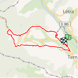
17.8 km | 27 km-effort
6h 7min
Yes
Trail Walking Val d'Oingt - Oingt (69) Beaujolais  - Photo
Walking
Thomasdanielle

Walking

Very easy
(1)
Val d'Oingt, Auvergne-Rhône-Alpes, Rhône, France
9.3 km | 13.3 km-effort
2h 30min
Yes
Trail Walking Saint-Vérand - Saint Vérand - Photo
Walking
fernand1254

Walking

Medium
(1)
Saint-Vérand, Auvergne-Rhône-Alpes, Rhône, France
13.5 km | 21 km-effort
3h 37min
Yes
Trail Walking Dième - Le Ruisseau de Brou - Photo
Walking
fernand1254

Walking

Medium
(1)
Dième, Auvergne-Rhône-Alpes, Rhône, France
11.3 km | 17.3 km-effort
3h 24min
Yes
Trail On foot Légny - De Saint Vérand à Bagnols - Photo
On foot
PRO

On foot

Easy
Légny, Auvergne-Rhône-Alpes, Rhône, France
7.4 km | 10.3 km-effort
2h 20min
No
Trail Walking Sainte-Paule - Sainte-Paule (13,4 km D. 485 m) - Photo
Walking
Thomasdanielle

Walking

Medium
(1)
Sainte-Paule, Auvergne-Rhône-Alpes, Rhône, France
13.4 km | 19.4 km-effort
4h 9min
Yes
Trail Walking Val d'Oingt - 69620-StLo-160412-Azergues+Genetière+Berthier - Photo
Walking
adye

Walking

Easy
(2)
Val d'Oingt, Auvergne-Rhône-Alpes, Rhône, France
5.2 km | 7.1 km-effort
1h 38min
Yes
Trail Walking Val d'Oingt - Saint-Laurent d'Oingt - Oingt, Plus beau Village de France - Photo
Walking
adye

Walking

Difficult
Val d'Oingt, Auvergne-Rhône-Alpes, Rhône, France
8.8 km | 12.5 km-effort
2h 20min
Yes
Trail Walking Val d'Oingt - 69620-Saint-Laurent d'Oingt-Bois d'Oingt : lavoirs, château et coteaux - Photo
Walking
adye

Walking

Medium
Val d'Oingt, Auvergne-Rhône-Alpes, Rhône, France
8 km | 11 km-effort
1h 57min
Yes


Close
My subscriptions