Trail Other activity Schattenhalb - Dossenhütte - Photo
 thomhed
thomhed

User

© OpenStreetMap contributors
Length
Length
2.8 km
Max alt
Max alt
2321 m
Uphill gradient
Uphill gradient
924 m
Km-Effort
Km-Effort  
12 km
Min alt
Min alt
1369 m
Downhill gradient
Downhill gradient
2 m
Boucle
Boucle
No
Creation date :
2014-12-11 00:00:00.0
Updated on :
2014-12-11 00:00:00.0

(0 Reviews)

Other activity
Other activity
--
Difficulty : Unknown

Scan this QR Code to open this trail in the SityTrail application

FREE GPS app for hiking

Logo SityTrail SityTrail

IGN / Geographical institutes

Download SityTrail from the App Store Download SityTrail from Google Play

Logo SityTrail SityTrail World

The world is yours!

Download SityTrail from the App Store Download SityTrail from Google Play Download SityTrail on Huawei AppGallery

About

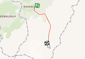
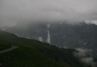
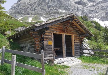
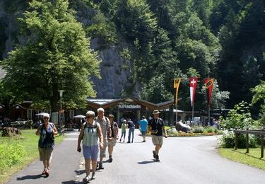
Trail Other activity of 2.8 km to be discovered at Bern, Interlaken-Oberhasli administrative district, Schattenhalb. This trail is proposed by thomhed.

Elevation profile

Positioning

Country:
Switzerland
Region :
Bern
Department/Province :
Interlaken-Oberhasli administrative district
Municipality :
Schattenhalb
Location:
Unknown
Start:(UTM)
435420 ; 5169742 (32T) N.

Trails nearby

Trail On foot Grindelwald - Scheidegg / Oberläger - Wildgärst - Photo
On foot
PRO

On foot

Easy
Grindelwald, Bern, Interlaken-Oberhasli administrative district, Switzerland
8.4 km | 19.1 km-effort
4h 19min
No
Trail On foot Grindelwald - Grosse Scheidegg - Scheidegg / Oberläger - Photo
On foot
PRO

On foot

Easy
Grindelwald, Bern, Interlaken-Oberhasli administrative district, Switzerland
5 km | 6.7 km-effort
1h 31min
No
Trail On foot Grindelwald - Grosse Scheidegg - Schreckfeld - Photo
On foot
PRO

On foot

Easy
Grindelwald, Bern, Interlaken-Oberhasli administrative district, Switzerland
5.2 km | 8.8 km-effort
2h 0min
No
Trail On foot Grindelwald - First - Grosse Scheidegg (Höhenweg 2400) - Photo
On foot
PRO

On foot

Easy
Grindelwald, Bern, Interlaken-Oberhasli administrative district, Switzerland
8.3 km | 15.3 km-effort
3h 28min
No
Trail On foot Meiringen - Pfanni - Scheidegg / Oberläger (Romantikweg) - Photo
On foot
PRO

On foot

Easy
Meiringen, Bern, Interlaken-Oberhasli administrative district, Switzerland
3.2 km | 5.6 km-effort
1h 16min
No
Trail On foot Meiringen - Pfanni - Scheidegg / Oberläger (Grindelband) - Photo
On foot
PRO

On foot

Easy
Meiringen, Bern, Interlaken-Oberhasli administrative district, Switzerland
3.1 km | 7.6 km-effort
1h 43min
No
Trail Other activity Grindelwald - ViaRegio_Jungfrau_3 - Photo
Other activity
GUIDE+

Other activity

Very easy
Grindelwald, Bern, Interlaken-Oberhasli administrative district, Switzerland
8.1 km | 11.3 km-effort
2h 16min
No
Trail Other activity Grindelwald - y10_grosse_scheidegg - Photo
Other activity
GUIDE+

Other activity

Very easy
Grindelwald, Bern, Interlaken-Oberhasli administrative district, Switzerland
15.7 km | 23 km-effort
5h 26min
No
Trail Walking Innertkirchen - Les gorges de l''Aar / Chutes du Reichenbach - Photo
Walking
Gianmario

Walking

Very easy
Innertkirchen, Bern, Interlaken-Oberhasli administrative district, Switzerland
7.8 km | 14.7 km-effort
3h 58min
Yes


Close
My subscriptions