Trail Walking Leymen - Heiligenbrunn - Photo
 dani0010
dani0010

User

© OpenStreetMap contributors
Length
Length
4.8 km
Max alt
Max alt
441 m
Uphill gradient
Uphill gradient
109 m
Km-Effort
Km-Effort  
6.3 km
Min alt
Min alt
330 m
Downhill gradient
Downhill gradient
111 m
Boucle
Boucle
Yes
Creation date :
2019-09-15 07:19:28.0
Updated on :
2019-09-15 08:39:07.666

(0 Reviews)

Walking
Walking
1h03
Difficulty : Unknown

Scan this QR Code to open this trail in the SityTrail application

FREE GPS app for hiking

Logo SityTrail SityTrail

IGN / Geographical institutes

Download SityTrail from the App Store Download SityTrail from Google Play

Logo SityTrail SityTrail World

The world is yours!

Download SityTrail from the App Store Download SityTrail from Google Play Download SityTrail on Huawei AppGallery

About

Trail Walking of 4.8 km to be discovered at Grand Est, Haut-Rhin, Leymen. This trail is proposed by dani0010.

Elevation profile

Positioning

Country:
France
Region :
Grand Est
Department/Province :
Haut-Rhin
Municipality :
Leymen
Location:
Unknown
Start:(UTM)
386002 ; 5261914 (32T) N.

Trails nearby

Trail Walking Biederthal - JD 15/20 Pedibus Biederthal - Photo
Walking
argonneuweg

Walking

(1)
Biederthal, Grand Est, Haut-Rhin, France
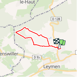
8.2 km | 11.4 km-effort
2h 33min
Yes
Trail Cycle Biel-Benken - 0110  1 Biel-Benken - Ferrette - Photo
Cycle
LCGsell

Cycle

Very easy
(1)
Biel-Benken, Basel-Landschaft, Bezirk Arlesheim, Switzerland
19.5 km | 24 km-effort
Unknown
No
Trail Walking Bättwil - Flüh - Mariastein - Laufen - Photo
Walking
GUIDE+

Walking

Very easy
Bättwil, Solothurn, Bezirk Dorneck, Switzerland
10.8 km | 17.9 km-effort
Unknown
No
Trail On foot Oltingue - Chateau du Landskron  - Photo
On foot
heurtinpatrick

On foot

Medium
Oltingue, Grand Est, Haut-Rhin, France
18.6 km | 27 km-effort
6h 6min
Yes
Trail Walking Hagenthal-le-Haut - rdpr 221220 apm - Photo
Walking
GUIDE
stempfel52

Walking

Easy
Hagenthal-le-Haut, Grand Est, Haut-Rhin, France
3.9 km | 5.2 km-effort
1h 3min
Yes
Trail Walking Hagenthal-le-Haut - rdpr 221220 matin - Photo
Walking
GUIDE
stempfel52

Walking

Difficult
Hagenthal-le-Haut, Grand Est, Haut-Rhin, France
9.3 km | 12.3 km-effort
2h 55min
Yes
Trail Mountain bike Leymen - Autour de Leymen  - Photo
Mountain bike
dani0010

Mountain bike

Medium
Leymen, Grand Est, Haut-Rhin, France
23 km | 30 km-effort
1h 25min
Yes
Trail Winter sports Ettingen - Region Basel 1 - Photo
Winter sports
Gacco

Winter sports

Very easy
Ettingen, Basel-Landschaft, Bezirk Arlesheim, Switzerland
25 km | 38 km-effort
Unknown
No
Trail Other activity Rodersdorf - BL Blauen (Rodersdorf - Zwingen) - Photo
Other activity
hrb

Other activity

Very easy
Rodersdorf, Solothurn, Bezirk Dorneck, Switzerland
12.9 km | 21 km-effort
Unknown
No


Close
My subscriptions