Trail Hybrid bike Molsheim - Molsheim - vers Strasbourg  - Photo

Molsheim - vers Strasbourg

© OpenStreetMap contributors
Length
Length
30 km
Max alt
Max alt
176 m
Uphill gradient
Uphill gradient
206 m
Km-Effort
Km-Effort  
33 km
Min alt
Min alt
147 m
Downhill gradient
Downhill gradient
208 m
Boucle
Boucle
Yes
Creation date :
2019-09-15 07:10:56.0
Updated on :
2019-09-15 09:52:22.916

(0 Reviews)

Hybrid bike
Hybrid bike
2h39
Difficulty : Easy

Scan this QR Code to open this trail in the SityTrail application

FREE GPS app for hiking

Logo SityTrail SityTrail

IGN / Geographical institutes

Download SityTrail from the App Store Download SityTrail from Google Play

Logo SityTrail SityTrail World

The world is yours!

Download SityTrail from the App Store Download SityTrail from Google Play Download SityTrail on Huawei AppGallery

About

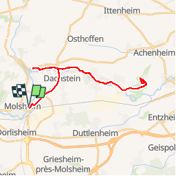
Trail Hybrid bike of 30 km to be discovered at Grand Est, Bas-Rhin, Molsheim. This trail is proposed by Pat_83200.

Description

Piste cyclable 30 kms

Elevation profile

Positioning

Country:
France
Region :
Grand Est
Department/Province :
Bas-Rhin
Municipality :
Molsheim
Location:
Unknown
Start:(UTM)
389262 ; 5377610 (32U) N.

Trails nearby

Trail Walking Mutzig - Les sanctuaires autour de Mutzig - Photo
Walking
VacheKiri67

Walking

Medium
(1)
Mutzig, Grand Est, Bas-Rhin, France
13.6 km | 17.9 km-effort
5h 0min
Yes
Trail Walking Wolxheim - wolxheim, chapelle st-denis. - Photo
Walking
jo-da

Walking

Medium
(1)
Wolxheim, Grand Est, Bas-Rhin, France
6.9 km | 8.3 km-effort
2h 19min
Yes
Trail Walking Mutzig - Les sanctuaires autour de Mutzig - Photo
Walking
tracegps

Walking

Difficult
(1)
Mutzig, Grand Est, Bas-Rhin, France
12.7 km | 16.8 km-effort
4h 0min
Yes
Trail Walking Dorlisheim - Escapade dans le vignoble de Dorlisheim - Photo
Walking
tracegps

Walking

Medium
(1)
Dorlisheim, Grand Est, Bas-Rhin, France
9.7 km | 12.6 km-effort
3h 0min
Yes
Trail Walking Mutzig - Autour du Fort de Mutzig - Photo
Walking
VacheKiri67

Walking

Difficult
(2)
Mutzig, Grand Est, Bas-Rhin, France
18.7 km | 26 km-effort
6h 30min
Yes
Trail Walking Molsheim - Les Chapelles entre vignoble et canal - Photo
Walking
VacheKiri67

Walking

Medium
(2)
Molsheim, Grand Est, Bas-Rhin, France
14.8 km | 17 km-effort
3h 43min
Yes
Trail On foot Rosheim - Circuit du Vignoble - Photo
On foot
PRO

On foot

Easy
Rosheim, Grand Est, Bas-Rhin, France
8.8 km | 11.7 km-effort
2h 38min
Yes
Trail Mountain bike Rosheim - schnacker tour le grand 8 circuit magique - Photo
Mountain bike
raphnou

Mountain bike

Difficult
(1)
Rosheim, Grand Est, Bas-Rhin, France
29 km | 39 km-effort
2h 30min
Yes
Trail Walking Rosenwiller - 2015-05-17 Marche Gourmande Rosenwiller - Photo
Walking
GUIDE
holtzv

Walking

Easy
(1)
Rosenwiller, Grand Est, Bas-Rhin, France
8.8 km | 11 km-effort
2h 23min
No


Close
My subscriptions