Trail Walking Orbey - Col du Wettstein - Hautes-Huttes - Lac du Forlet - Lac Vert - Photo

Col du Wettstein - Hautes-Huttes - Lac du Forlet - Lac Vert

© OpenStreetMap contributors
Length
Length
14.6 km
Max alt
Max alt
1171 m
Uphill gradient
Uphill gradient
449 m
Km-Effort
Km-Effort  
21 km
Min alt
Min alt
884 m
Downhill gradient
Downhill gradient
448 m
Boucle
Boucle
Yes
Creation date :
2019-09-15 08:42:59.622
Updated on :
2019-09-15 19:10:52.85

(0 Reviews)

Walking
Walking
4h41
Difficulty : Medium

Scan this QR Code to open this trail in the SityTrail application

FREE GPS app for hiking

Logo SityTrail SityTrail

IGN / Geographical institutes

Download SityTrail from the App Store Download SityTrail from Google Play

Logo SityTrail SityTrail World

The world is yours!

Download SityTrail from the App Store Download SityTrail from Google Play Download SityTrail on Huawei AppGallery

About

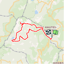
Trail Walking of 14.6 km to be discovered at Grand Est, Haut-Rhin, Orbey. This trail is proposed by VacheKiri67.

Description

Faite le 15/09/2019. Beau parcours. Balisage : rectangle jaune - disque jaune - croix jaune - rectangle jaune. Bonnes chaussures indispensables. La pause peut être faite au Chalet Erichson du club vosgien où les repas tirés du sac sont autorisés à condition d'y acheter les boissons.

Elevation profile

Photos

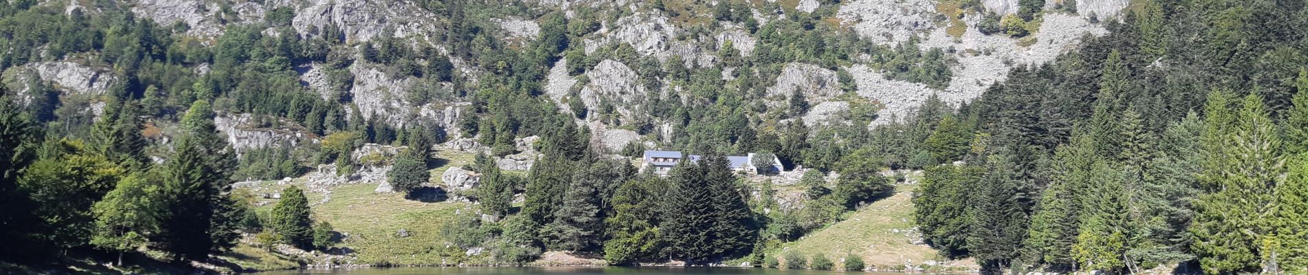
21 photos in total. Please click on a photo to see them all in the gallery.

Positioning

Country:
France
Region :
Grand Est
Department/Province :
Haut-Rhin
Municipality :
Orbey
Location:
Unknown
Start:(UTM)
359850 ; 5327933 (32U) N.

Trails nearby

Trail Horseback riding Orbey - 2020-06-28 WE Orbey Petit Hohnack Glasborn - Photo
Horseback riding
GUIDE
holtzv

Horseback riding

Difficult
(1)
Orbey, Grand Est, Haut-Rhin, France
22 km | 31 km-effort
4h 5min
Yes
Trail Horseback riding Orbey - 2020-06-27 WE Orbey Noir Gazon Vert Forlet - Photo
Horseback riding
GUIDE
holtzv

Horseback riding

Medium
(1)
Orbey, Grand Est, Haut-Rhin, France
21 km | 30 km-effort
3h 59min
Yes
Trail Other activity Soultzeren - Totom 4 lacs - Photo
Other activity
dinozore

Other activity

Medium
(1)
Soultzeren, Grand Est, Haut-Rhin, France
15.6 km | 26 km-effort
4h 37min
Yes
Trail Walking Hohrod - Circuit historique 1914-18 Hohrodberg - Linge - Photo
Walking
VacheKiri67

Walking

Medium
(1)
Hohrod, Grand Est, Haut-Rhin, France
14 km | 19.8 km-effort
5h 50min
Yes
Trail Walking Orbey - Le Tour du Lac Blanc par le Rocher Hans et le sentier de crête - Photo
Walking
tracegps

Walking

Difficult
(3)
Orbey, Grand Est, Haut-Rhin, France
4.4 km | 7.7 km-effort
2h 30min
Yes
Trail Walking Soultzeren - Tanet-Gazon du faing par lac vert et retour sommet du Tanet - Photo
Walking
ride-in-Elsass

Walking

Medium
(1)
Soultzeren, Grand Est, Haut-Rhin, France
10 km | 15.6 km-effort
4h 24min
Yes
Trail Mountain bike Orbey - Lac Blanc  - Têtes des Faux - Photo
Mountain bike
tracegps

Mountain bike

Medium
(1)
Orbey, Grand Est, Haut-Rhin, France
15.3 km | 21 km-effort
1h 0min
Yes
Trail Horseback riding Gunsbach - Le petit Hohnack - verkort (23) - Photo
Horseback riding
eddyvermeulen1

Horseback riding

Easy
(1)
Gunsbach, Grand Est, Haut-Rhin, France
13.1 km | 18.4 km-effort
2h 25min
Yes
Trail Horseback riding Orbey - gite pre au bois gazon du Faing lac blanc lac noir - Photo
Horseback riding
IsaFal

Horseback riding

Medium
(1)
Orbey, Grand Est, Haut-Rhin, France
17.2 km | 25 km-effort
3h 17min
Yes


Close
My subscriptions