Trail Walking Pontechianale - pointe Johanne ou lossetta - Photo

pointe Johanne ou lossetta

 gibello
gibello

User

© OpenStreetMap contributors
Length
Length
13.7 km
Max alt
Max alt
3035 m
Uphill gradient
Uphill gradient
1042 m
Km-Effort
Km-Effort  
28 km
Min alt
Min alt
2012 m
Downhill gradient
Downhill gradient
1039 m
Boucle
Boucle
Yes
Creation date :
2019-09-19 06:45:20.859
Updated on :
2019-09-19 15:22:34.961

(1 Reviews)

Walking
Walking
6h00
Difficulty : Difficult

Scan this QR Code to open this trail in the SityTrail application

FREE GPS app for hiking

Logo SityTrail SityTrail

IGN / Geographical institutes

Download SityTrail from the App Store Download SityTrail from Google Play

Logo SityTrail SityTrail World

The world is yours!

Download SityTrail from the App Store Download SityTrail from Google Play Download SityTrail on Huawei AppGallery

About

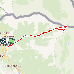
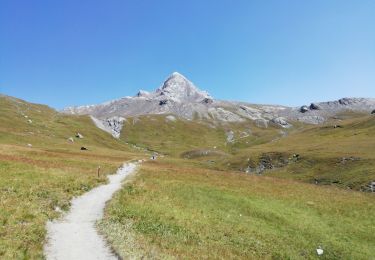
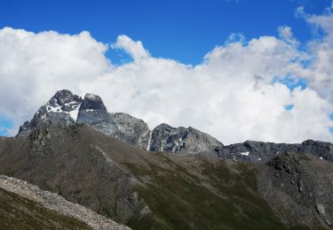
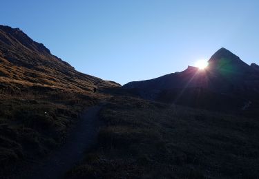
Trail Walking of 13.7 km to be discovered at Piemont, Cuneo, Pontechianale. This trail is proposed by gibello.

Description

départ franges de l rio

Elevation profile

Photos

Positioning

Country:
Italy
Region :
Piemont
Department/Province :
Cuneo
Municipality :
Pontechianale
Location:
Unknown
Start:(UTM)
340875 ; 4947382 (32T) N.

Comments

Please log in to post a review or rate the element


Trails nearby

Trail On foot Pontechianale - (SI E21) Pontechianale, Borgata Maddalena - Rifugio Quintino Sella - Photo
On foot
PRO

On foot

Medium
Pontechianale, Piemont, Cuneo, Italy
14.1 km | 28 km-effort
6h 25min
No
Trail Walking Molines-en-Queyras - le tour du Pain de Sucre - Photo
Walking
GUIDE
amiral13

Walking

Difficult
Molines-en-Queyras, Provence-Alpes-Côte d'Azur, Hautes-Alpes, France
8.1 km | 16 km-effort
4h 57min
Yes
Trail Walking Molines-en-Queyras - Lacs Foréant, Egorgéou, Baricle et de l'Eychassier - Photo
Walking
GUIDE
amiral13

Walking

Medium
Molines-en-Queyras, Provence-Alpes-Côte d'Azur, Hautes-Alpes, France
13.8 km | 24 km-effort
6h 20min
Yes
Trail Walking Molines-en-Queyras - le pain de sucre - Photo
Walking
GUIDE
amiral13

Walking

Difficult
(1)
Molines-en-Queyras, Provence-Alpes-Côte d'Azur, Hautes-Alpes, France
4.5 km | 10.1 km-effort
4h 39min
Yes
Trail Walking Pontechianale - pain de sucre circuit  - Photo
Walking
Youcef Atallah

Walking

Medium
Pontechianale, Piemont, Cuneo, Italy
5.9 km | 11.9 km-effort
2h 12min
No
Trail Walking Molines-en-Queyras - Pic Foréant et Col d'Asti - Photo
Walking
PapouBertrand

Walking

Very difficult
Molines-en-Queyras, Provence-Alpes-Côte d'Azur, Hautes-Alpes, France
11.8 km | 24 km-effort
7h 14min
No
Trail Walking Molines-en-Queyras - 05-Pain-de-sucre-6.5km-525m-aout21 - Photo
Walking
SyMA

Walking

Medium
Molines-en-Queyras, Provence-Alpes-Côte d'Azur, Hautes-Alpes, France
6.5 km | 13.5 km-effort
4h 14min
Yes
Trail Walking Molines-en-Queyras - Refuge Agnel-lac Foreant-col Agnel 23 07 2020 - Photo
Walking
Hugues Michel

Walking

Medium
Molines-en-Queyras, Provence-Alpes-Côte d'Azur, Hautes-Alpes, France
8.2 km | 14.8 km-effort
3h 20min
Yes
Trail Walking Molines-en-Queyras - Tour du Viso J6 - Le Pain de sucre - Photo
Walking
patjobou

Walking

Difficult
Molines-en-Queyras, Provence-Alpes-Côte d'Azur, Hautes-Alpes, France
7 km | 14.7 km-effort
4h 30min
Yes


Close
My subscriptions