Trail Walking Ormoy-Villers - SM_ORMOY-VILLERS_8.0Km - Photo

SM_ORMOY-VILLERS_8.0Km

 GR77LP
GR77LP

User

© OpenStreetMap contributors
Length
Length
8 km
Max alt
Max alt
145 m
Uphill gradient
Uphill gradient
95 m
Km-Effort
Km-Effort  
9.2 km
Min alt
Min alt
98 m
Downhill gradient
Downhill gradient
96 m
Boucle
Boucle
Yes
Creation date :
2019-09-22 19:41:58.636
Updated on :
2021-06-22 15:40:08.03

(5 Reviews)

Walking
Walking
2h13
Difficulty : Medium

Scan this QR Code to open this trail in the SityTrail application

FREE GPS app for hiking

Logo SityTrail SityTrail

IGN / Geographical institutes

Download SityTrail from the App Store Download SityTrail from Google Play

Logo SityTrail SityTrail World

The world is yours!

Download SityTrail from the App Store Download SityTrail from Google Play Download SityTrail on Huawei AppGallery

About

Trail Walking of 8 km to be discovered at Hauts-de-France, Oise, Ormoy-Villers. This trail is proposed by GR77LP.

Description

Pkg Cimètiere
https://www.goelerando.fr/
DAMMARTIN en GOËLE 77

Elevation profile

Photos

Positioning

Country:
France
Region :
Hauts-de-France
Department/Province :
Oise
Municipality :
Ormoy-Villers
Location:
Unknown
Start:(UTM)
488794 ; 5449192 (31U) N.

Comments

Please log in to post a review or rate the element


Trails nearby

Trail Walking Versigny - SM_DROIZELLES_ 8Km - Photo
Walking
GR77LP

Walking

Medium
(4)
Versigny, Hauts-de-France, Oise, France
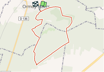
8 km | 8.9 km-effort
2h 1min
Yes
Trail Walking Péroy-les-Gombries - SM_PEROY-LES-GOMBRIES_8.4KM - Photo
Walking
GR77LP

Walking

Medium
(3)
Péroy-les-Gombries, Hauts-de-France, Oise, France
8.4 km | 9.5 km-effort
2h 5min
Yes
Trail Walking Auger-Saint-Vincent - SM_AUGER-Saint-VINCENT_8.8Km - Photo
Walking

Walking

Easy
(2)
Auger-Saint-Vincent, Hauts-de-France, Oise, France
8.9 km | 9.7 km-effort
2h 7min
Yes
Trail Walking Ormoy-Villers - Geocache Ancienne sablière - Photo
Walking
patcaillou

Walking

Very easy
(1)
Ormoy-Villers, Hauts-de-France, Oise, France
3.3 km | 3.9 km-effort
1h 10min
Yes
Trail Cycle Boissy-Fresnoy - Voie verte du Valois - Photo
Cycle
gilbertdu60

Cycle

Easy
Boissy-Fresnoy, Hauts-de-France, Oise, France
34 km | 40 km-effort
2h 17min
Yes
Trail Motor Crépy-en-Valois - Randoguide - Photo
Motor
bum1664

Motor

Medium
(1)
Crépy-en-Valois, Hauts-de-France, Oise, France
64 km | 78 km-effort
5h 26min
No
Trail Walking  - SM_ROSIERES-NORD_8.6Km - Photo
Walking
GR77LP

Walking

Medium
, Hauts-de-France, Oise, France
8.6 km | 9.9 km-effort
2h 14min
Yes
Trail Hybrid bike Lévignen - Voie verte de Valois - Photo
Hybrid bike
katiab

Hybrid bike

Difficult
Lévignen, Hauts-de-France, Oise, France
31 km | 36 km-effort
2h 58min
Yes
Trail Walking  - Grand Ormoy-Villers tour - Photo
Walking
Humog60

Walking

Medium
, Hauts-de-France, Oise, France
12.2 km | 13.8 km-effort
2h 18min
Yes


Close
My subscriptions