Trail Nordic walking Sainte-Ode - Marche nordique NW1+NW2 - Le Tour du Rancourt - Photo

Marche nordique NW1+NW2 - Le Tour du Rancourt

© OpenStreetMap contributors
Length
Length
7.5 km
Max alt
Max alt
501 m
Uphill gradient
Uphill gradient
135 m
Km-Effort
Km-Effort  
9.3 km
Min alt
Min alt
409 m
Downhill gradient
Downhill gradient
136 m
Boucle
Boucle
Yes
Creation date :
2019-09-23 17:09:41.88
Updated on :
2021-02-07 17:08:06.454

(0 Reviews)

Nordic walking
Nordic walking
2h06
Difficulty : Medium

Scan this QR Code to open this trail in the SityTrail application

FREE GPS app for hiking

Logo SityTrail SityTrail

IGN / Geographical institutes

Download SityTrail from the App Store Download SityTrail from Google Play

Logo SityTrail SityTrail World

The world is yours!

Download SityTrail from the App Store Download SityTrail from Google Play Download SityTrail on Huawei AppGallery

About

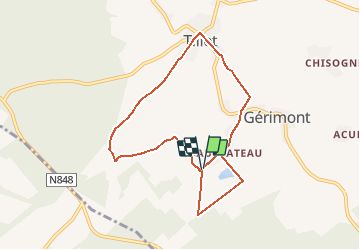
Trail Nordic walking of 7.5 km to be discovered at Wallonia, Luxembourg, Sainte-Ode. This trail is proposed by denissculier.

Description

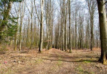
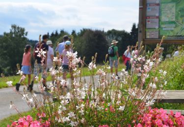
Cet itinéraire de marche nordique est formé par deux parcours en boucle. Il fait partie de l'Ardenne Nordic Park (www.ardenne-nordic-park.be). La plus petite des boucles suit un parcours très facile, plat, passant en bord de champs et en bord de bois. La seconde boucle est davantage vallonnée; elle rejoint le ruisseau de Rancourt et traverse le village de Tillet.

Elevation profile

Positioning

Country:
Belgium
Region :
Wallonia
Department/Province :
Luxembourg
Municipality :
Sainte-Ode
Location:
Tillet
Start:(UTM)
681340 ; 5541213 (31U) N.

Trails nearby

Trail On foot Libramont-Chevigny - Remagne étang gpx - Photo
On foot
GUIDE+

On foot

Easy
(1)
Libramont-Chevigny, Wallonia, Luxembourg, Belgium
7.5 km | 9.5 km-effort
2h 9min
Yes
Trail Walking Sainte-Ode - RB-LUX-08 - Raccourci - De part et d’autre de l’Ourthe occidentale - Photo
Walking
PRO

Walking

Difficult
(2)
Sainte-Ode, Wallonia, Luxembourg, Belgium
15.2 km | 18.6 km-effort
4h 13min
Yes
Trail Walking Sainte-Ode - Tonny - Promenade de Tonny (A6) - Photo
Walking
GUIDE+

Walking

Medium
(3)
Sainte-Ode, Wallonia, Luxembourg, Belgium
9.5 km | 12.2 km-effort
2h 36min
Yes
Trail Walking Sainte-Ode - Beauplateau - Promenade du Pleurotte (T7) - Photo
Walking
GUIDE+

Walking

Medium
(2)
Sainte-Ode, Wallonia, Luxembourg, Belgium
5.5 km | 6.9 km-effort
1h 29min
Yes
Trail Walking Sainte-Ode - Amberloup, Natura 2000 - Des sites qui valent le détour. Lx11 - Photo
Walking
GUIDE+

Walking

Easy
(4)
Sainte-Ode, Wallonia, Luxembourg, Belgium
4.2 km | 5 km-effort
1h 6min
Yes
Trail Walking Sainte-Ode - RB-LUX-08 - De part et d’autre de l’Ourthe occidentale - Photo
Walking
PRO

Walking

Medium
(1)
Sainte-Ode, Wallonia, Luxembourg, Belgium
23 km | 29 km-effort
6h 14min
Yes
Trail Walking Sainte-Ode - Beauplateau - Le sentier du Coprin (GTA 4) - Photo
Walking
GUIDE+

Walking

Very difficult
(2)
Sainte-Ode, Wallonia, Luxembourg, Belgium
16.6 km | 20 km-effort
4h 20min
Yes
Trail Walking Sainte-Ode - Tonny - Promenade de bois Cousin (A7) - Photo
Walking
GUIDE+

Walking

Medium
(2)
Sainte-Ode, Wallonia, Luxembourg, Belgium
5.8 km | 7.9 km-effort
1h 40min
Yes
Trail Walking Sainte-Ode - Magerotte - Promenade des Haies de Magery (T4) - Photo
Walking
GUIDE+

Walking

Medium
(3)
Sainte-Ode, Wallonia, Luxembourg, Belgium
9.3 km | 11.4 km-effort
2h 29min
Yes


Close
My subscriptions